


DELMARVA - A soggy stretch of weather is in store for Sussex County from late Wednesday through late Thursday evening, as an evolving storm system brings waves of rainfall and potential thunderstorms to the Delmarva Peninsula.
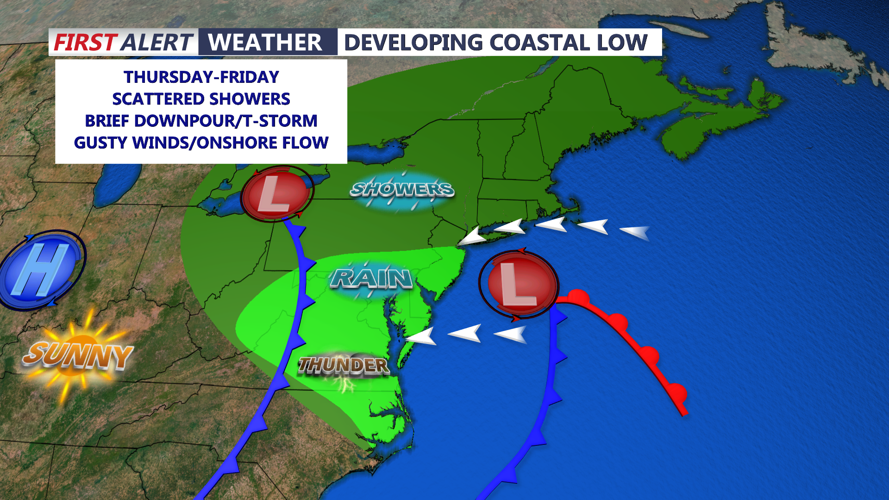
A pair of low-pressure systems are responsible for this unsettled pattern. The primary low remains over the Ohio Valley and eastern Great Lakes region, while a secondary low is developing over the Mid-Atlantic coast. This secondary system is expected to track offshore tonight before curving north along the coast through Thursday, reaching near Montauk Point by the end of the day.
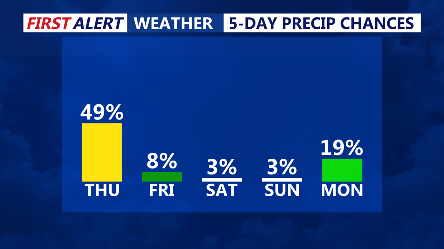
As this system strengthens, Sussex County residents can expect another wave of rain to move in from the west late Wednesday evening, accompanied by weak shortwave energy in the upper atmosphere. While there may be brief lulls in precipitation, forecasters warn these breaks will be unpredictable. Rain will become more widespread and heavier overnight, with rainfall totals around half an inch likely for much of southern Delaware. Rainfall amounts will be higher in coastal areas farther north, including parts of New Jersey.
Overnight showers may be accompanied by a few isolated thunderstorms, particularly as stronger shortwaves pass through the region. Urban and poor drainage flooding is possible by Thursday morning, especially in areas with heavier downpours.
By Thursday morning, rain will begin transitioning to lighter, more scattered showers. Conditions will remain damp and cool through the day, with highs expected in the 50s to low 60s. An additional round of isolated afternoon showers or thunderstorms is possible as another disturbance approaches from the west.
The pattern remains unsettled into Thursday night, with lingering showers continuing into Friday. While Friday and Saturday won’t be washouts, occasional showers and cooler-than-normal temperatures are expected. Highs will hover in the low to mid-60s through Saturday.
Improvement arrives Sunday as the upper-level low exits the region and high pressure attempts to build in. However, a new developing low-pressure system to the south could bring renewed rain chances early next week, depending on its eventual track.
