


DELMARVA - After Friday’s murky finish, the first part of the weekend offers a brief reset for Sussex County and beach communities from Fenwick Island to Ocean City — but it comes with caveats for anyone on the water and anyone trying to get ahead of a higher-impact stretch expected later Sunday into Monday.
Off the Delaware coast, a Small Craft Advisory remains posted until 6 a.m. Saturday for Atlantic waters that include the stretch from Cape May to Cape Henlopen and from Cape Henlopen to Fenwick Island, where lingering 4- to 5-foot seas and choppy conditions can make handling difficult for smaller boats. Farther south near Ocean City, the Small Craft Advisory continues until 7 p.m. Friday, then conditions improve for much of Saturday before the next system builds in.
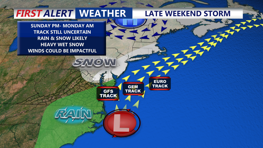
A Gale Watch is posted for Sunday evening through Monday afternoon for the coastal waters near Ocean City and for adjacent Delaware coastal waters, signaling the potential for dangerous winds and rapidly building seas as the storm strengthens offshore.
On land in Sussex County, a Winter Storm Watch is in effect from 1 p.m. Sunday until 6 p.m. Monday, and a Coastal Flood Watch is posted from 9 p.m. Sunday until 5 a.m. Monday.
What to expect early Saturday through early Sunday
Early Saturday: Clouds thin after daybreak as drier air works in, with improving visibility and a cooler, steadier breeze. For most travelers, Saturday morning is a return to normal driving — but mariners should note the final hours of the small-craft headline early Saturday before conditions settle.
Saturday afternoon: A quieter, brighter stretch sets up. Highs reach near 51 in Georgetown and near 47 in Ocean City, with clouds giving way to sun at times and only a light to moderate northwest breeze.
Saturday night into early Sunday: Clouds increase and a chance of rain develops after about 1 a.m., with the risk of damp roads expanding toward sunrise Sunday. Lows dip to around 32 in Sussex County and around 36 at the beaches, keeping the early wave primarily rain for most spots near the coast. By Sunday morning, winds begin to turn more easterly and pick up ahead of the storm, setting the stage for a wetter, breezier Sunday that later turns more hazardous.
How to use the calm stretch to prepare
Saturday is the best window to tighten plans before watches take on more urgency later Sunday: top off essentials and prescriptions, charge devices, and line up snow and ice tools where they’re easy to grab. In coastal areas of Sussex, the overnight Coastal Flood Watch starting Sunday night is a reminder to clear storm drains and move vehicles from flood-prone streets and lots before Sunday evening.
For the Ocean City and Delaware nearshore waters, conditions improve Saturday, but the Gale Watch later Sunday means boat owners and marinas should use daylight Saturday to check lines, secure loose gear and plan to be in safe harbor well before Sunday evening.
