


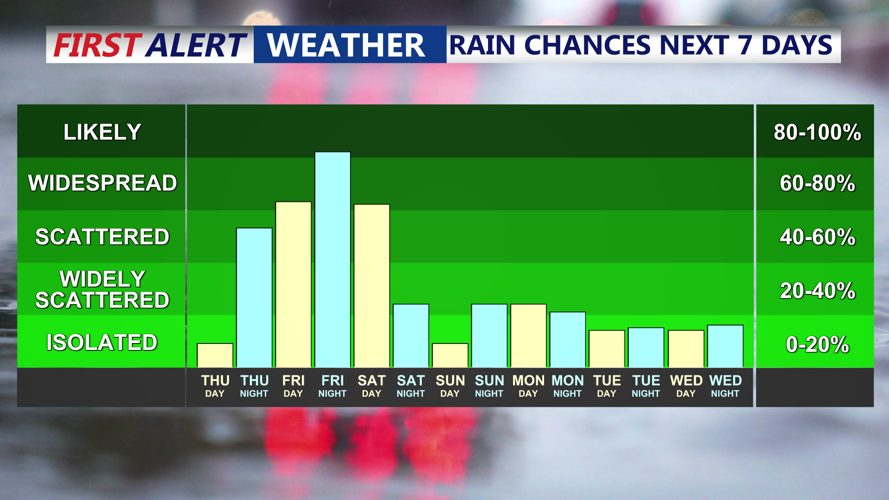


DELMARVA - A streak of unsettled weather is forecast to impact the Delaware beach region beginning late Thursday evening and continuing through early Saturday, with periods of heavy rain, thunderstorms, and a chance for severe weather, particularly on Friday.
After a gray and cooler-than-expected Thursday, a new disturbance moving northeast across Delmarva will bring occasional showers and thunderstorms overnight. Locally heavy rainfall is possible, with overnight lows dipping into the low 60s for coastal areas.
Friday will remain humid as weak high pressure attempts to stabilize conditions. However, another round of scattered showers is expected by the afternoon, with skies staying mostly cloudy. Temperatures will climb into the mid to upper 70s across Sussex County. The Storm Prediction Center places the area under a marginal risk for severe weather, with damaging winds as the primary concern.
By Friday night, a developing low-pressure system tracking along a stalled frontal boundary will bring more widespread rain and thunderstorms. The risk for severe weather will continue, especially in southern areas like Bethany Beach, Rehoboth Beach and Fenwick Island. Rainfall could be locally heavy, although widespread flooding is not anticipated at this time. Overnight temperatures will drop into the mid to upper 50s.
Saturday brings another potential for strong storms as a cold front pushes through the region in the afternoon. Once again, damaging wind gusts will be the primary threat, especially given the elevated instability over Delmarva. Highs will reach the low 70s before the front sweeps offshore, ushering in cooler and drier air by Saturday night. Lows will retreat into the 50s along the coast.
By Sunday night, conditions are expected to improve significantly with only a slight chance for lingering showers. Fair and milder weather will return heading into next week, with highs reaching the low to mid-70s on Monday and warming into the 80s by midweek.