


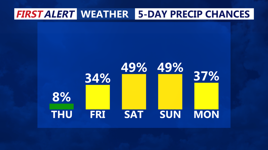


DELMARVA - Sussex County residents should prepare for changing weather conditions beginning early Thursday morning and continuing through early Saturday. A quiet start to the period will gradually shift toward a more active pattern, with increasing chances of rain and thunderstorms.
Thursday morning will begin dry under the influence of a weakening high-pressure system that has lingered across the Ohio River Valley. This system will keep skies generally fair across southern Delaware, with light southwest winds and comfortable humidity levels. Temperatures will rise into the upper 70s to low 80s by midday.
By late Thursday afternoon, however, the weather picture starts to shift. A cold front approaching from the northwest will introduce more moisture and instability into the region. While the highest risk of showers and storms lies across northeast Pennsylvania and northern New Jersey, Sussex County may still see isolated showers or a stray thunderstorm Thursday evening. If any storms do reach the area, they may produce brief gusty winds and locally heavy rainfall due to elevated moisture levels in the atmosphere, with PW values reaching up to 1.5 inches.
Friday will be a transitional day as high pressure slides offshore and a stationary front becomes draped across the Mid-Atlantic. Moisture will increase, and by Friday afternoon, isolated showers may begin to develop across the region. Shortwave energy arriving from the west may enhance this activity into the evening, especially across Delmarva, where the atmosphere becomes more unstable.
By Friday night, rain chances increase significantly as a low-pressure system tracks through the Delmarva Peninsula. Scattered thunderstorms are possible overnight, especially where instability peaks near the low’s center. While widespread severe weather is not expected, locally heavy rain could impact parts of Sussex County due to elevated dew points and moisture-rich air.
Rain is likely to persist into early Saturday morning, tapering gradually as the low departs. Another round of showers may redevelop later Saturday, but the early morning period will likely mark the peak of precipitation.
Residents are advised to monitor local forecasts for updates and to be aware of the potential for brief heavy downpours, especially late Friday into early Saturday. Roads may become slick, and localized ponding of water is possible in low-lying areas.