


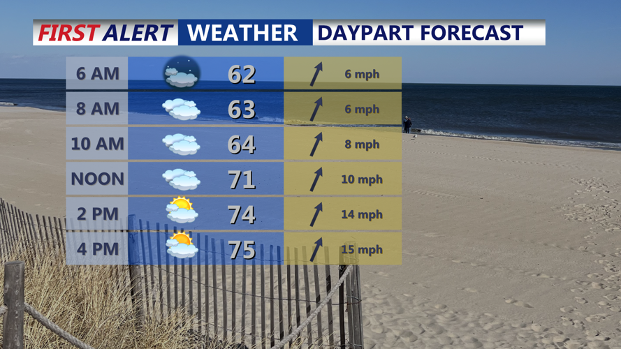


DELMARVA -- Sunday will feature unseasonably mild conditions across the region, with highs in the mid to upper 70s inland and upper 60s to low 70s along the coast. Mostly cloudy skies are expected throughout the day as a stationary front lingers across the region. That front will begin to lift northward as a warm front Sunday night, gradually ushering warmer air into the area.

Look for cloudy skies and highs in the mid to upper 70s.
A few isolated showers could develop along this front Sunday night due to upper-level energy, but widespread rain is not expected until Monday. Temperatures will be non-diurnal, meaning they will slowly rise overnight. Overnight lows in the low 60s will be reached early, with temperatures ticking up into the upper 50s to low 60s by sunrise Monday.
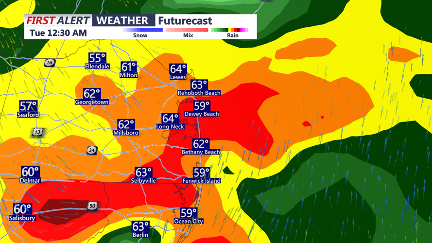
By Monday afternoon, a strong cold front will approach from the northwest, bringing increasing rain chances and the potential for thunderstorms. While areas north and west of the I-95 corridor are likely to see the earliest and heaviest activity, much of Delmarva is expected to feel the impacts after sunset, mainly during the nighttime hours.
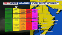
The Storm Prediction Center has placed the region under a slight risk for severe weather, with damaging wind gusts the primary concern. While widespread instability is limited due to cloud cover, the atmosphere will remain dynamic with strong shear and elevated moisture levels. Pre-frontal showers and thunderstorms may develop during the day, though coverage remains uncertain.

Some storms Monday night could turn severe producing damaging winds.
By Monday night, a strengthening low-level jet will bring moisture levels to near-climatological highs for this time of year, with precipitable water values around 1.5 inches.

Torrential downpours and damaging winds possible Monday night as a powerful cold front moves through.
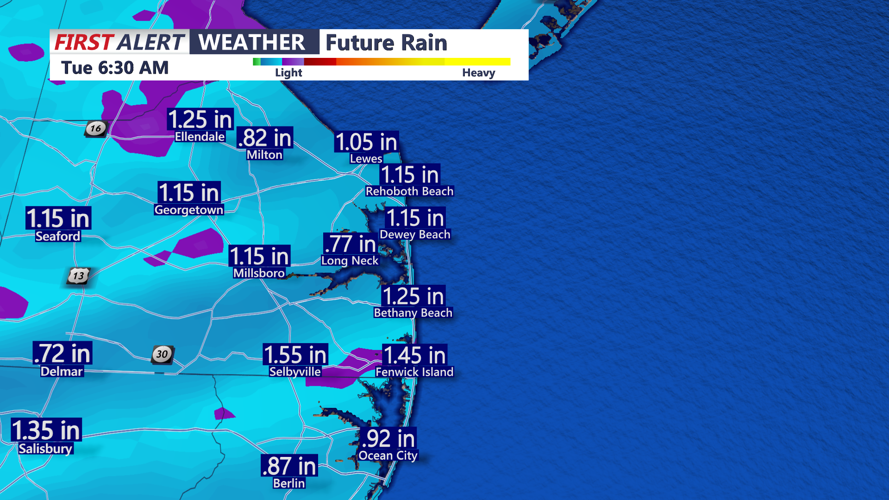
Rainfall totals of 0.75 to 1.25 inches are expected, with locally higher amounts possible. Despite Delmarva’s ongoing drought, localized flooding may occur in urban or poorly drained areas due to high rainfall rates.

Rainfall Monday afternoon-early Tuesday could be 0.50"-1.50"
Once the front moves through overnight, temperatures will fall into the 50s by early Tuesday. Sunshine will gradually return Tuesday as high pressure builds in, though northwest winds will gust up to 30 mph in the morning before relaxing in the afternoon. Highs will reach the upper 50s.
Tuesday night will bring the coldest air of the week as a Canadian air mass settles over the region. Lows may dip near or below freezing away from the coast, especially in areas where the growing season begins April 1. While frost advisories or freeze warnings are not yet anticipated, we are monitoring the potential.
By Wednesday, skies will start partly sunny before cloud cover increases ahead of the next system. Highs will remain in the 50s.
The end of the week looks more unsettled as multiple waves of low pressure move through the area between Thursday and Saturday. While details remain uncertain, forecasters expect multiple chances for rain and clouds during this period, with temperatures rebounding into the 60s and 70s.
