


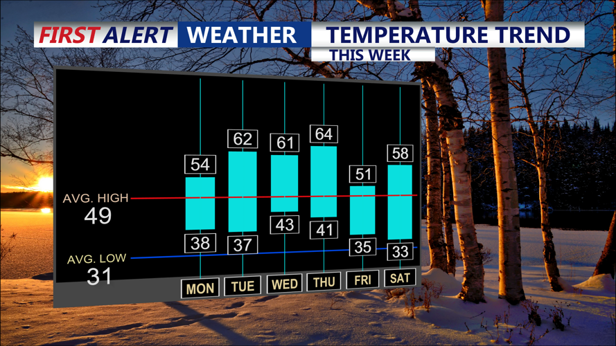


DELMARVA -- A warm start to the final week of February. Most of the day will be sunny, with temperatures reaching several degrees above normal—topping off in the low to mid 50s. However, as the day progresses, an upper trough with shortwave energy will approach from the west, increasing cloud cover. South to southwest winds will pick up to 10–15 mph, with gusts reaching up to 20 mph in the afternoon.
A quick-moving minor shortwave disturbance will cross just north of the area Monday night, bringing additional clouds. Although the night will be seasonably chilly, temperatures will rebound on Tuesday, climbing well above normal into the lower 60s. A weak cold front is expected to cross the region later on Tuesday, but high pressure will briefly maintain control.

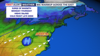
Thawing out across the east after an arctic outbreak last week.
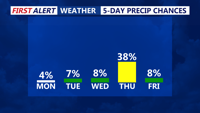
High pressure returns on Wednesday, allowing for a milder and relatively stable weather pattern into early Thursday. Expect above-normal conditions with highs again in the upper 50s to low 60s on Thursday. However, a stronger cold front is forecast to move through on Thursday, potentially bringing increased cloud cover and a chance for rain as it interacts with a low pressure system.

Not expecting any precipitation until a cold front Thursday, it will be rain.
After the passage of Thursday’s system, temperatures are predicted to drop to more normal levels on Friday. The pattern then shifts again, with another bump in the highs for Saturday. Looking ahead to Sunday, temperatures are expected to trend back below normal, signaling a cooler start for the following week. Two distinct weather features—a low pressure system and its accompanying fronts (one on Thursday/Thursday night and a stronger one for late Saturday into early Sunday)—will introduce intermittent chances for rain across the region.