


Delmarva stays bright but chilly today, with highs nearly 10 degrees below average in the upper 40s to near 50. Milder, dry weather settles in through midweek before a sharp warm-up Thursday, followed by rain Thursday night into Friday and a cooler, dry weekend.
From
To

Today stays below average across Delmarva with partly sunny skies, highs in the upper 30s to low 40s, and a cold east-northeast wind off the ocean keeping conditions raw. Tonight turns partly cloudy with lows in the upper 20s to low 30s. The chill lingers Thursday before a warmer trend arrives Friday, the first day of spring, with highs near 60. Even warmer air builds in for the weekend, pushing temperatures into the 60s Saturday and low 70s inland Sunday before showers and cooler air return early next week.

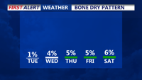
Sunny skies, low humidity, and below-average temperatures will define Delmarva’s Labor Day Weekend as high pressure settles in. Nights will be especially chilly, with inland areas dipping into the 40s. Dry weather is expected through midweek before showers become possible with a cold front Thursday.

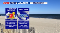
High pressure will dominate Delmarva’s weather this Labor Day Weekend, bringing sunny skies, low humidity, and below-average temperatures. Nights will be chilly, with some inland areas dipping into the 40s. Dry conditions continue into next week before a cold front arrives Thursday.

Delmarva will enjoy a sunny and comfortable Sunday, with highs in the upper 70s to low 80s and a moderate rip current risk from Delaware beaches through Chincoteague. Overnight lows will dip into the 50s inland and 60s at the coast. High pressure will weaken early next week, bringing a warming trend into the upper 80s and low 90s by Tuesday. Midweek turns hotter and more humid, with a surface trough and cold front increasing the chances for showers and storms Wednesday and Thursday. The front may stall into the weekend, keeping the forecast unsettled.

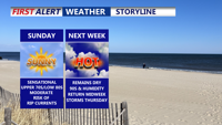
Delmarva will enjoy another sunny and comfortable day on Sunday, with highs in the upper 70s to low 80s — several degrees below normal for early August. A moderate rip current risk will remain in effect for Delaware beaches through Chincoteague, and swimmers are urged to stay near lifeguards. Overnight lows will dip into the 50s inland and 60s near the coast. High pressure will weaken early in the week, bringing a warming trend that pushes highs into the upper 80s to low 90s by Tuesday. Midweek turns hotter and more humid.

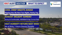
Unseasonably cool weather will stick around through the weekend, with sunny skies and below-average temperatures continuing Sunday. Overnight lows will dip into the 50s inland and 60s at the coast, with a moderate rip current risk from Delaware beaches to Chincoteague. A gradual warm-up begins early next week, leading into hotter and more humid conditions by midweek, with a chance of storms Wednesday and Thursday.


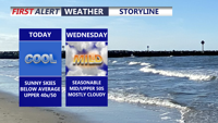
A strengthening coastal low will bring steady rain, strong onshore winds, and below-average temperatures to the Delaware beaches and inland Sussex County from early Wednesday through early Friday.

Strong high pressure moving in from the Midwest will dominate Delmarva’s weather through Wednesday, maintaining dry and cool conditions with clear skies and patchy frost overnight.

A strong high-pressure system moving in from the Midwest will keep Delmarva dry and cool through midweek. Expect chilly overnight lows with patchy frost inland, followed by a crisp, sunny Wednesday with below-average temperatures.