


From early Thursday through early Friday, Sussex County’s beach communities will see persistent cloud cover, seasonable temperatures, and a low chance of spotty sprinkles before milder, wetter weather approaches overnight.
From
To


High pressure will bring warm, dry weather to Delmarva on Sunday for Mother’s Day, with highs nearing the low 80s. Cloud cover increases Monday as a low-pressure system approaches, leading to scattered showers by Monday night and Tuesday. Rain chances linger midweek before a warmer, unsettled pattern returns for the weekend.

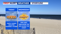
Patchy fog gives way to partly sunny skies and warm temperatures. A mix of isolated showers and storms will punctuate the rest of the week as multiple upper-level systems move through the region, bringing cooler temperatures and increased rain chances into the weekend.

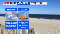
Delmarva will enjoy a calm and clear start to the week under high pressure, with temperatures gradually rising through midweek. A weak cold front will bring a chance of showers late Monday night into early Tuesday, followed by a stretch of sunshine through Thursday. Another frontal system could impact the region Friday into Saturday, bringing possible rain and cooler air for the weekend.

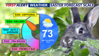
Easter Sunday afternoon brings dry and breezy conditions to Delmarva as high pressure builds in. The region stays seasonably cool through Tuesday with brief cloud cover and a pair of cold fronts. Dry and warmer weather follows midweek before another system increases rain chances late Friday into Saturday.


Easter Sunday kicks off a stretch of mostly dry and seasonable weather for Delmarva, with high pressure keeping skies bright and breezy through midweek. A pair of cold fronts will move through early in the week, with rain chances increasing toward the end of the week as a new system approaches from the west.

Delmarva will see a stretch of dry and mild weather beginning Monday, with sunshine and highs in the low to mid-60s inland and 50s along the coast. Southwest winds will push temperatures even higher Tuesday before a midweek cooldown. A backdoor cold front will briefly lower temperatures Wednesday before shifting north again, allowing a warming trend into the weekend. Highs could reach the low 70s by Saturday, with rain chances returning Sunday night.

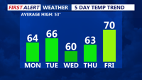
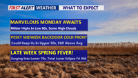
Delmarva will enjoy a stretch of mild and dry weather through the upcoming week, with temperatures gradually warming into the mid-60s to low-70s by the weekend. A backdoor cold front will briefly cool things down midweek before shifting northward, allowing temperatures to rebound. The next significant chance of rain arrives Sunday night with an approaching cold front.

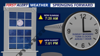
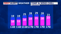
A cold and clear Saturday night will bring temperatures down into the 20s across Delmarva, but warmer days are ahead. Don't forget to set those clocks ahead an hour tonight. Sunday remains breezy with highs in the 50s, followed by a gradual warming trend through the week. By midweek, highs will reach the 60s, with temperatures possibly touching the low 70s by next Saturday.

Delmarva will face frigid temperatures as an Arctic high-pressure system brings some of the coldest weather in years. Lows may dip into the single digits Sunday night, with daytime highs struggling to rise above the upper 20s to low 30s. A weak system could bring light snow or rain showers late Monday into Christmas Eve, followed by moderating temperatures heading into the holiday weekend.