


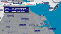
A Cold Weather Advisory covers Sussex County through Monday morning as wind chills stay near or below zero, with clouds increasing and temperatures moderating by early Tuesday
From
To

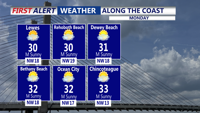
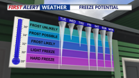
Bitter cold and subzero wind chills will hold on in Sussex County late Sunday night into Monday morning before temperatures rebound to the low 30s Monday afternoon.


DEMA announced Tuesday morning that Governor Matt Meyer has lifted the Level 1 driving warnings in both Kent and New Castle County, effective at 11 a.m.


Community members across Delaware are making their final trips to grocery, and hardware stores. However, C.R. McLeod, the Director of Community Relations at DelDOT says they will be fully staffed by later tonight.


CoastTV Meteorologists anticipate that some parts of Delaware could receive up to eight inches of snow, sounding the alarms for first responders.

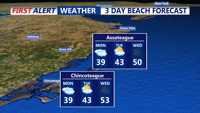
Sussex County will be sunny and mild Tuesday, then turn partly cloudy and breezier overnight into early Wednesday.

Sussex County will stay mostly clear and chilly late Monday evening, then turn sunny and milder through late Tuesday evening.

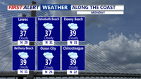
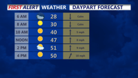
A strong cold front Sunday evening ushered in a blast of arctic air, setting up a much colder and breezy Monday across Sussex County.

A sharp cold front brings much colder, drier air into Sussex County this afternoon through tomorrow, with gusty winds today and the coldest temperatures of the season arriving Monday night into Tuesday.

After Wednesday morning rain exits, Sussex County enters a cloudy, mostly dry stretch with areas of drizzle possible and cool temperatures holding through early Thursday.