


Four teams from Selbyville Middle School earned top honors at a regional drone competition, with one team qualifying for a championship event in West Virginia.
From
To

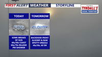
A stalled front keeps Delmarva dreary and foggy today, with the coolest, foggiest weather hugging the coast while inland areas briefly break into sunshine and warmer temperatures. Fog and drizzle linger into tonight and early Friday, then a backdoor cold front reinforces cooler, cloudier conditions. The pattern flips this weekend as warmer air pushes back in, turning noticeably milder Sunday and especially early next week with a few chances for showers and even a thunderstorm.

Light to moderate rain moves across Delmarva this afternoon into the evening with temperatures in the mid 40s, then exits later tonight. Friday turns bright and milder near 50, with Saturday the pick of the weekend near 60 and sunshine. A dry front slips through Sunday, and we’re monitoring the potential for accumulating snow Monday night into Tuesday morning, though confidence remains low for now.


Eastern Shore and Southern Maryland Senators Steve Hershey, Johnny Mautz, Mary Beth Carozza, and Jack Bailey are continuing to push state and federal officials to protect Maryland’s commercial watermen after a devastating winter season.

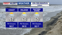
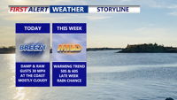
Clouds stick around, but a mild southwest breeze pushes Delmarva into the mid to upper 50s today, with some inland spots near 60° and gusts 25–30 mph. Tonight stays damp and mild with patchy fog and a spotty sprinkle possible. A backdoor cold front cools some areas Thursday, then rain moves in Thursday night into Friday, with 0.50" to 1.00" possible. The weekend starts quiet and dry, but Sunday night into Monday bears watching for a potential coastal low that could bring rain changing to snow—still uncertain this far out.

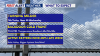
High pressure slipping offshore sets up a south to southwest breeze, kicking off a stretch of above-normal temperatures across Delmarva. A warm front Wednesday could bring a few late-day showers and push highs near 60°, followed by a possible backdoor cold front that may split the region Thursday into Friday. Another system brings a better chance of rain Friday into Saturday, and there’s early, uncertain potential for a more impactful storm later this weekend—possibly including snow—depending on track and available cold air.

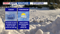
Mostly cloudy and chilly with a stiff northeast onshore wind—gusts near the coast up to 30–35 mph and highs only in the upper 30s to low 40s. A big warm-up arrives Tuesday through Thursday, with highs pushing into the 50s and low 60s, before periods of rain Thursday night into Friday and another rain-focused system Friday into Saturday. Cooler air returns for the weekend, with a still-uncertain system possible late Sunday.

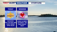
Delmarva gets a wall-to-wall sunny Friday but it stays about 10° below average with northwest wind gusts up to 20 mph. Tonight turns clear and cold, dropping into the low to mid 20s. Valentine’s Day looks lovely with mostly sunny skies and highs in the upper 40s to low 50s. Clouds increase late Saturday night and Sunday turns cloudy, topping out in the mid to upper 40s. Early next week, confidence is rising in a warmer, faster system favoring the coastal plain, bringing mainly rain

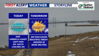
Today brings a noticeable thaw across Delmarva with highs in the upper 40s to low 50s, but it stays blustery with northwest gusts up to 35 mph. Cooler, breezy weather returns Thursday and Friday, followed by a beautiful Valentine’s Day near 50 degrees. Attention then turns to a potential storm late Sunday into Monday, with track and impacts still uncertain.