


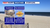
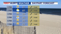
Thursday on Delmarva will be warm and muggy under partly sunny skies, with highs ranging from the mid-80s to lower 90s. Scattered showers and thunderstorms are expected to develop in the afternoon and evening, and while severe weather is not anticipated, some storms could bring locally heavy rain and minor flash flooding. A weak cold front will move through, settling south of the region Thursday night. Conditions gradually dry out Friday and Saturday, though a stray shower or storm remains possible. Another cold front arrives late Sunday, followed by cooler, less humid air early next week.
From
To

A stormy Sunday with widespread showers and thunderstorms, heavy rain potential, and an isolated severe storm threat. Humidity and heat will make it feel near 100 degrees before storms arrive. A clearing trend returns Monday and Tuesday, but heat builds again before a stronger cold front cools things down for next weekend.

Delmarva faces an unsettled Sunday with showers and thunderstorms, some potentially severe with damaging winds and localized flash flooding. A warm front moves through ahead of a weak cold front Sunday night, followed by a hot and humid start to the week before a stronger midweek cold front brings relief heading into next weekend.

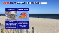
A warm front lifting into Delmarva Saturday night will bring clouds, muggy conditions, and a chance for storms, some of which could be strong with gusty winds. Sunday will feature periods of showers and thunderstorms before skies clear Monday, leading into a hot and humid start to the week. A midweek cold front promises relief by Friday and next weekend.

Saturday on Delmarva brings warm, humid conditions with only a slight chance of late-day showers or storms. Sunday is expected to be wetter, with heavy rain and flash flooding possible.

A cold front will bring storms late Friday, followed by slightly cooler and less humid conditions Saturday before unsettled weather returns Saturday night.

Delmarva faces another bout of extreme summer heat with heat indices topping 100 degrees Friday. A cold front offers slight relief overnight, but unsettled weather and humidity will linger through the weekend.

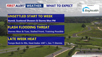
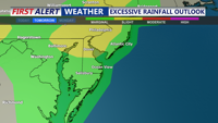
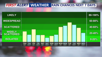
Delmarva will experience humid, foggy nights and a stretch of unsettled weather through midweek. Beginning Sunday night, areas of mist and patchy fog will develop, especially along the coast. A cold front approaching late Monday will trigger showers and thunderstorms, with the primary concern being heavy rain and flash flooding. While the severe thunderstorm risk is low, locally gusty winds cannot be ruled out. The front is expected to stall through Wednesday, keeping rain chances high before heat and humidity surge again later in the week.

A stalled front lingering over the Delmarva Peninsula will keep the region humid through the weekend, with occasional showers and storms. Although conditions will ease somewhat compared to midweek, isolated flash flooding and strong wind gusts remain possible. A stronger cold front will arrive early next week, bringing more widespread storms and a gradual drying trend.

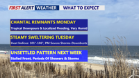
Beginning Sunday night, Delmarva will enter a period of high humidity and unsettled weather. The remnants of Tropical Storm Chantal will bring rounds of showers and thunderstorms Monday and Tuesday, with locally heavy rainfall and potential flash flooding. Severe storms possible Tuesday afternoon/evening. A stalled cold front will keep the region stormy through late week, while oppressive heat and humidity push heat index values to near 106 degrees.