


Hot and humid weather will grip Delmarva through midweek, then relief to start the month of August with increasing rain chances.
From
To


Delmarva faces another bout of extreme summer heat with heat indices topping 100 degrees Friday. A cold front offers slight relief overnight, but unsettled weather and humidity will linger through the weekend.

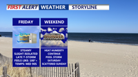
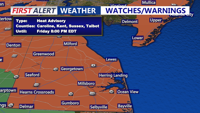
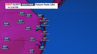
Delmarva will see dangerous heat and humidity Friday, with heat index values reaching up to 108 degrees and a Heat Advisory in effect. A cold front arriving late Friday will bring a chance of isolated storms, mainly north of Sussex County, before lingering near the region through Saturday and lifting north as a warm front Sunday. The weekend will be unsettled but not a total washout, with additional storm chances Sunday night. High pressure returns Monday before another frontal system arrives midweek.

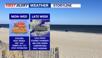
Delmarva will experience a warm, muggy Thursday night followed by dangerously high heat on Friday, prompting a Heat Advisory. A cold front late Friday will bring a chance of isolated storms, mainly north of Sussex County, before lingering near the region over the weekend. While Saturday and Sunday won’t be complete washouts, scattered showers and thunderstorms are expected, with another front approaching Sunday night. High pressure will bring drier conditions Monday, but more storms are expected by midweek.


With temperatures rising throughout the day and a heat advisory issued for July 25, the Delaware Electric Cooperative has issued a "Beat the Peak" alert from 4 p.m. to 6 p.m. on July 24. According to the co-op, "Beat the Peak" alerts are issued when the cost to purchase and produce power for members is high. This alert comes after temperatures are expected to hit the upper 80s and near 90 degrees later on July 24 and temperatures on July 25 are expected to reach 100 to 107 degrees

Sussex County will see rising temperatures and humidity through Friday, with dangerous heat and evening storm chances before relief arrives late Friday night.

High pressure keeps Sussex County dry through Thursday, but dangerous heat and the chance of severe storms arrive Friday as a cold front approaches.


Saturday brought tropical downpours and flash flooding to parts of Delmarva, especially in Worcester County. While not everyone saw rain, Ocean City and Berlin were inundated with 3 to 4 inches of rainfall in just a few hours. A muggy night with lingering showers will be followed by heat and the threat of isolated severe storms Sunday. A cold front is expected to bring relief into early next week before humidity builds again by the end of the week.


A weak cold front will bring relief from oppressive heat late Thursday, but unsettled conditions return for the weekend with a risk of showers and storms.


With feels-like temperatures soaring well past 100 degrees Thursday, communities across Delmarva are working to protect their most vulnerable, both human and animal.