


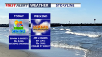
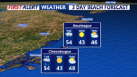
Today officially began spring at 10:46 this morning, and Delmarva is enjoying mostly sunny skies, mild temperatures, and increasing southwest winds gusting 30 to 35 mph. Clouds will build this evening ahead of a quick-moving system bringing light showers overnight into early Saturday, with rainfall totals staying under a quarter inch and showers ending by around 8 a.m. Saturday. The weekend stays mild, with highs in the 50s and 60s Saturday and well into the 70s inland Sunday, before a stronger cold front arrives Monday with showers, gusty winds, and much colder air to start next week.
From
To


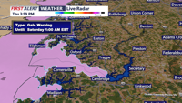
Today on Delmarva, a powerful storm system will bring the risk of strong to severe thunderstorms this afternoon into tonight, with damaging winds as the primary concern and an increasing threat for isolated tornadoes. Even outside of storms, southerly winds will gust from 35 to 45 mph, with some areas seeing gusts up to 50 mph. Heavy rainfall may lead to localized flash flooding, especially inland, while Sussex County faces minor coastal flooding along the back bays including Rehoboth Bay and Little Assawoman Bay. Conditions turn cooler and dry Tuesday through Wednesday before temperatures gradually moderate later in the week, with the next chance for showers arriving Friday night into Saturday.

Gusty winds and a sharp temperature drop will define conditions in Sussex County from early Friday morning through early Saturday morning as a cold front moves through the region.

A developing coastal system will bring widespread rain to Sussex County from early Tuesday through Tuesday night, followed by colder, drier weather midweek.


Sussex County sees increasing clouds Tuesday with rain developing by midday and continuing into the night.


A cold front will bring cooler and drier air to Sussex County Monday evening, followed by a stretch of sunny, seasonable weather through midweek before rain chances return later in the week.


A shift to a cooler, breezier weather pattern is underway across Delmarva following a cold front early Monday. Temperatures will dip into the mid-60s with gusty west-northwest winds before rebounding slightly into the low 70s Tuesday ahead of another front. The rest of the week will feature mostly dry conditions with showers late Tuesday, breezy afternoons, and high pressure returning by the weekend

Sussex County will see cooler temperatures and strong winds Monday before conditions calm overnight, ahead of another cold front set to arrive late Tuesday.


A cold front will bring showers, gusty winds, and a slight tornado risk overnight into early Monday before cooler, breezy conditions settle in across Sussex County.


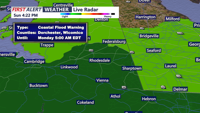
High pressure building from the Great Lakes will keep skies clear and temperatures cool across Delmarva through Friday, with gusty northwest winds and possible patchy frost overnight. Conditions moderate slightly into the weekend before a strong cold front brings rain Sunday night into Monday, followed by another blast of cool air.