


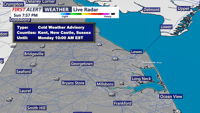
Bitter cold and subzero wind chills will hold on in Sussex County late Sunday night into Monday morning before temperatures rebound to the low 30s Monday afternoon.
From
To


High pressure moves in late Sunday evening, bringing a colder, dry night and a mainly sunny, seasonable Monday in Sussex County.


A brief round of snow early Sunday gives way to bitter cold, gusty winds and wind chills in the single digits through Monday morning in Sussex County.

A strong cold front Sunday evening ushered in a blast of arctic air, setting up a much colder and breezy Monday across Sussex County.


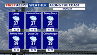
Rain ends Sunday evening as temperatures tumble and high pressure settles in Monday.

Light rain ends early Sunday evening before colder, gusty conditions settle in.

Temperatures stay cold and winds remain brisk from late Sunday evening through late Monday evening.

Sussex County will enjoy a calm and clear end to the weekend with mild temperatures and light winds before clouds and rain arrive later in the week.

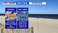
Sunday brings warm, humid conditions with rip current dangers along the coast. A cold front early in the week will usher in cooler, drier air, bringing a September-like feel as Labor Day weekend approaches.

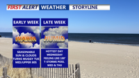
Delmarva begins the week with patchy morning fog Monday, followed by sunny skies and highs in the mid to upper 80s. Temperatures climb into the upper 80s and low 90s by Tuesday and Wednesday, with increasing humidity. A cold front is expected late week, bringing only a slight chance for showers or storms before warm, mostly dry conditions return for the weekend.