


Light rain and patchy fog late tonight are expected to give way to a dry, warmer Thursday across Sussex County.
From
To

Sussex County could see patchy fog early Friday, followed by mainly dry weather through Saturday morning as a cold front moves through late Friday night.

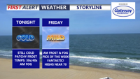
A milder night in Sussex County will reduce the frost threat, but patchy fog and low clouds could develop before a mainly dry Friday.


Near record warmth this afternoon, Easter Sunday becomes rainy with storms possible.

Patchy fog early Saturday in Sussex County should give way to warm, mostly sunny weather, while Easter sunrise services early Sunday morning look mostly dry but increasingly cloudy before showers become likely later in the morning.

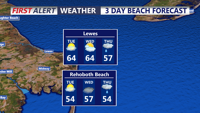
Patchy fog and mild conditions are expected late Friday night in Sussex County, with a warm Saturday inland, cooler air at the beaches and a chance that a back-door cold front turns the afternoon cloudier and cooler than earlier forecasts suggested.


Lingering rain early Thursday should give way to cooler, variable conditions before a warm front brings a chance of light rain and patchy fog late Thursday night into early Friday.

Fog early Tuesday is expected to give way to sunshine and springlike warmth before patchy fog returns late Tuesday night into early Wednesday.


A gloomy, damp day continues across Delmarva with highs in the upper 40s to low 50s inland. Scattered showers and drizzle develop this evening and overnight with patchy fog and lows in the mid to upper 40s. Temperatures trend much warmer midweek into early next week (10–20° above average), though a back-and-forth front late week could create sharp north/south temperature differences and several chances for showers—plus a small thunder risk Thursday night.


Sussex County starts Tuesday with clouds and patchy fog, then turns milder with some afternoon clearing. Clouds thicken Tuesday night, and a few showers could arrive toward early Wednesday as the next system approaches.