


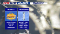
A hard freeze is expected inland Monday night, while Sussex County’s beach communities stay colder than normal but likely above freezing before milder air returns Tuesday.
From
To

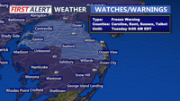
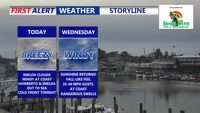
Today starts a much cooler stretch across Delmarva with mostly cloudy skies, highs in the mid 50s, and gusty winds. The biggest concern is tonight, when a widespread freeze is expected inland with a Freeze Warning in effect from midnight to 9 AM Tuesday. After a chilly Tuesday, temperatures rebound into the 60s and 70s by mid to late week before cooler weather and a better chance of rain return for the weekend.

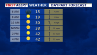
Sussex County is set for a sharp drop to around 9 degrees Tuesday night, then a sunnier, less harsh Wednesday with highs reaching the 30s and low 40s — warmest near the coast.

Delmarva stays sunny and dry today, but an arctic front tonight brings brutal wind chills and the coldest air of the week on Tuesday.

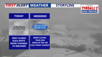
A coastal low brings light snow and a changeover to rain along the beaches today, chilly dry weekend under mostly cloudy skies before a colder pattern settles in early next week.


A chilly, sunny start to the week on Delmarva gives way to clouds and a quick round of rain Tuesday night into early Wednesday, with milder temperatures arriving late week.

Cooler air settles in for the end of the week with mostly dry, breezy days and cold, clear nights that may bring patchy frost inland.

Winds ease overnight before a weak front ushers in cooler, breezy weather and possible isolated showers on Thursday.

High pressure gives way to an approaching cold front tonight, bringing a fall-like airmass into Delmarva. While rain isn’t expected, breezy coastal winds and cooler-than-average temperatures will mark the midweek forecast before a warm-up this weekend.

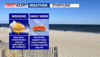
Delmarva will enjoy a stretch of sunny, comfortable weather from Saturday through Monday, with only light breezes and mild temperatures. However a HIGH risk of rip currents remains for all beach points in Delaware, to Ocean City to Chincoteague. Conditions will heat up by midweek, with highs in the 90s, rising humidity, and a chance for scattered afternoon storms.