


High pressure moving in from the north will push Hurricane Humberto and Imelda out to sea, bringing sunny skies and seasonable temperatures to Delmarva. Coastal winds and dangerous rip currents, however, remain a concern through the week.
From
To

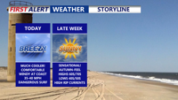
Delmarva will see another warm, humid day Wednesday with highs in the low to mid-80s and a high rip current risk along the coast. Can't rule out an isolated shower or storm this evening. Thursday is a Yellow Alert Day, with the potential for severe storms bringing damaging winds as a cold front approaches the region.

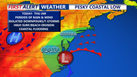
A coastal low moving north from the Carolinas is bringing scattered showers, gusty northeast winds and dangerous surf conditions to the Delmarva Peninsula Tuesday. The system will weaken into Wednesday, followed by a cold front Friday and a stretch of dry, pleasant weather into the weekend and early next week.

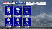
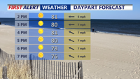
Delmarva can expect a calm Tuesday with highs in the low to mid-70s before a developing offshore low brings showers tonight into Wednesday. Breezy coastal winds and a HIGH risk of rip currents remain in effect from Delaware Beaches to Assateague.

Sunny skies, low humidity, and below-average temperatures will define Delmarva’s Labor Day Weekend as high pressure settles in. Nights will be especially chilly, with inland areas dipping into the 40s. Dry weather is expected through midweek before showers become possible with a cold front Thursday.

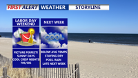
High pressure will dominate Delmarva’s weather this Labor Day Weekend, bringing sunny skies, low humidity, and below-average temperatures. Nights will be chilly, with some inland areas dipping into the 40s. Dry conditions continue into next week before a cold front arrives Thursday.

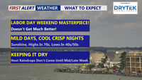
High pressure will bring sunny skies, low humidity, and below-average temperatures to Delmarva this Labor Day weekend, with overnight lows dipping into the 50s—and even the 40s in some inland areas. Dry weather continues into next week before a cold front approaches late Thursday.

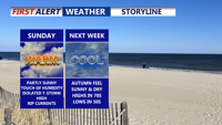
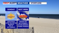
Sunday brings warm, humid conditions with rip current dangers along the coast. A cold front early in the week will usher in cooler, drier air, bringing a September-like feel as Labor Day weekend approaches.

Delmarva will enjoy a sunny and comfortable Sunday, with highs in the upper 70s to low 80s and a moderate rip current risk from Delaware beaches through Chincoteague. Overnight lows will dip into the 50s inland and 60s at the coast. High pressure will weaken early next week, bringing a warming trend into the upper 80s and low 90s by Tuesday. Midweek turns hotter and more humid, with a surface trough and cold front increasing the chances for showers and storms Wednesday and Thursday. The front may stall into the weekend, keeping the forecast unsettled.

Delmarva will enjoy another sunny and comfortable day on Sunday, with highs in the upper 70s to low 80s — several degrees below normal for early August. A moderate rip current risk will remain in effect for Delaware beaches through Chincoteague, and swimmers are urged to stay near lifeguards. Overnight lows will dip into the 50s inland and 60s near the coast. High pressure will weaken early in the week, bringing a warming trend that pushes highs into the upper 80s to low 90s by Tuesday. Midweek turns hotter and more humid.