


DELMARVA - Our region will remain under the grip of arctic air and gusty winds through Wednesday and Thursday, as an upper-level trough amplifies across the East Coast. While no precipitation is expected, cold and windy conditions will dominate, keeping temperatures far below seasonal averages.
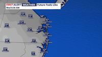
Wednesday will bring daytime highs that struggle to escape the 20s, with wind chills lingering in the teens throughout the day. Winds will remain brisk, with sustained speeds of 20-30 mph and occasional gusts up to 40 mph. The biting cold will make outdoor conditions uncomfortable, and residents are urged to bundle up and limit outdoor exposure.
Wednesday night temperatures will again drop into the teens, with wind chills dipping into the single digits across much of the region. Higher elevations could see subzero wind chill readings. Cloud cover will increase at times, though no precipitation is expected as a series of shortwaves move through the upper-level trough.
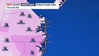
Thursday will offer little reprieve as gusty winds persist, driven by a tight pressure gradient across the area. Wind speeds will remain in the 20-30 mph range, with peak gusts of 30-40 mph likely during the day. Highs on Thursday will remain below freezing, adding to the arctic feel.
By Thursday night, the cyclonic flow aloft will begin to ease slightly, and the pressure gradient will weaken heading into Friday. While temperatures will remain below average, winds will diminish, offering some relief to the region as high pressure builds from the west.
Residents should secure outdoor objects, dress in layers, and take precautions against the cold. Although the weather will remain dry, the combination of strong winds and frigid temperatures makes for hazardous conditions, especially for those spending extended time outdoors.