


DELMARVA -- After a weak coastal low brought light rain across Delmarva earlier today, skies are clearing from west to east as a cold front approaches this evening. Rainfall totals averaged between a quarter and a third of an inch across southern Delmarva, while northern areas saw little measurable precipitation.

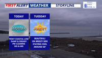
Clearing skies through the afternoon and evening, turning breezy with the passage of a cold front.
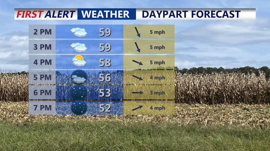
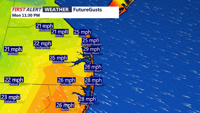
Highs today will range from the upper 50s to low 60s. As the front sweeps offshore tonight, winds will shift abruptly to the west-northwest at 10 to 20 mph, with occasional gusts reaching up to 30 mph.

A cold front pushes through this evening northwest winds gusting 25-30 mph.
The air behind the front will be drier rather than sharply colder, with dewpoints falling into the 30s and overnight temperatures dipping into the low to mid-40s by Tuesday morning.

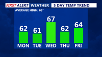
Wednesday will be the mildest day over the next five days.
Tuesday will bring plenty of sunshine and brisk northwest winds of 10 to 20 mph, with gusts still near 30 mph at times. Afternoon highs will again reach the upper 50s to low 60s.
By Tuesday night some patchy frost is possible into Wednesday morning. High pressure will regain control, allowing for quieter and slightly warmer weather. Temperatures will climb into the upper-60s to near 70, under mostly sunny skies, though another weak front is expected to brush by the region late Wednesday with little impact other than a few clouds to the north.
The pattern remains calm through Thursday before a stronger, more active system approaches by the weekend. Multiple waves of low pressure could bring rounds of showers Friday night and again on Sunday, though timing and intensity remain uncertain.
Could see some of our coldest airmass of the season early next week where many of us could dip at or below freezing Monday and Tuesday nights.