


DELMARVA - A powerful coastal storm is battering Delaware’s beaches Sunday night, bringing damaging onshore winds, coastal flooding, and rain that will linger into early Monday before conditions gradually improve through late Tuesday.
The system’s rain shield continued to expand westward, with low-level moisture producing drizzle and lowered cloud bases across the region. A strong easterly jet stream roughly 2,500 feet above the ground is funneling winds of 45 to 55 mph just offshore, enhancing lift and helping rainfall spread inland overnight.
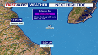
The most significant impacts will remain along coastal communities, where gusts have already reached 45 to 59 mph. A High Wind Warning remains in effect for coastal Sussex County through 6 a.m. Monday, while a Wind Advisory is in place for inland areas through the same time.
Rainfall totals along the coast have ranged from half an inch to one inch so far, with final totals expected to approach two inches before tapering off. Inland areas will likely see less than an inch overall. The storm’s main threats remain severe coastal flooding and strong winds, with rainfall posing a lesser risk.
Winds are forecast to remain strongest into the early morning hours of Monday before gradually easing before daybreak. Breezy conditions will persist through the day, with gusts near 30 mph inland and up to 40 mph along the beaches. Temperatures Monday will remain in the upper 50s to low 60s under overcast skies and scattered rain, with lows in the low to mid-50s overnight.
By Tuesday morning, the departing system will allow conditions to improve. Lingering clouds and a few showers may persist early, but skies will brighten by afternoon, with highs in the mid to upper 60s. Dry, stable weather is expected Tuesday night and Wednesday as high pressure builds into the region.