


DELMARVA - Expect a cooler pattern Friday morning as a backdoor cold front settles south through the region, replacing Thursday’s warm and breezy conditions with a more seasonable feel.
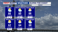
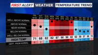
Through the morning, skies are expected to turn partly to mostly cloudy as northeast winds remain light. The cooler air mass will keep temperatures from rising as much as they did a day earlier, with afternoon highs generally reaching the upper 60s to around 70 inland, while beach areas stay a bit cooler.
The added moisture in the air and reduced wind speeds should also lower the fire weather risk that had been elevated Thursday under dry and gusty conditions.
By Friday evening, the region should remain mostly cloudy and cool, with winds beginning to take on a more easterly direction as high pressure over eastern Canada starts feeding in an onshore flow. That ocean breeze will continue through the overnight hours, helping keep temperatures chilly by late April standards.
Early Saturday morning is expected to be mostly cloudy and cool, with lows settling in the 40s to near 50. While the steadier rain tied to an approaching low-pressure system is expected to hold off until later in the weekend, the trend into Saturday morning will be toward a damp, raw setup heading into a wet and unsettled period.
