


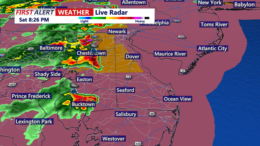


DELMARVA - Residents across Sussex County should stay weather aware Saturday evening as strong to severe thunderstorms continue to threaten the area during the final hours of a dangerous holiday weather day.
Severe Thunderstorm Watch No. 459 remains in effect until 11 p.m. for the entire region. The greatest concern is damaging wind gusts that could knock down tree limbs, bring down power lines and make travel dangerous with little warning. Heavy rain, frequent lightning and localized flash flooding also remain possible, especially in areas hit by repeated storms.
The most dangerous window is underway now and will continue through late evening. Storms that develop or move into Sussex County could strengthen quickly in the hot, unstable air left behind from the day’s extreme heat. People outside for Saturday evening plans, beach gatherings or holiday events should move indoors as soon as thunder is heard and avoid waiting until storms are overhead.
The excessive heat headlines expired at 8 p.m., but the region is not out of danger. The approaching storms and rain will help bring cooler conditions overnight, but the impacts of several days of extreme heat may still be felt, especially for older adults, young children, outdoor workers and anyone without reliable cooling.
Drivers should watch for sudden downpours, ponding on roads and water covering low-lying or poor-drainage areas. Never drive through flooded roads. Lightning, even away from the heaviest rain, can still strike miles from a storm.
The severe weather threat is expected to decrease overnight, but heavy rain may linger in spots. Sunday will bring somewhat lower temperatures, with highs generally in the low 90s across Delmarva, but humidity will remain high and more showers and thunderstorms are expected. Additional rounds of storms Sunday and Monday may bring more severe weather and a continuing risk of flash flooding.
Drier weather is not expected to fully return until the middle of next week, once the stalled front finally pushes south of the region.
