


High pressure will move offshore by late Friday, allowing for the arrival of the next weather system. Dry conditions will persist through the evening, but precipitation is expected to develop across the region between 9 p.m. and midnight. Temperatures at the surface will range from the upper 20s to mid-30s, setting the stage for potential freezing rain in some areas.
Saturday Early Morning:
The main concern overnight into early Saturday is freezing rain, which could create slippery conditions on untreated roadways, sidewalks, and bridges. Freezing rain is most likely along and north of the Interstate 78 corridor, particularly in the southern Poconos, Lehigh Valley, and parts of New Jersey, where a Winter Weather Advisory is in effect until 9 a.m. Saturday. Elsewhere on the Delmarva Peninsula, precipitation will fall as plain rain. Temperatures are expected to gradually rise after midnight, with most locations above freezing by sunrise.
Saturday Mid-Morning:
By mid-morning, most of the region will have transitioned to rain as temperatures continue to rise. Areas south of Interstate 78 will experience steady rain, with total rainfall amounts ranging from 0.10 to 0.50 inches, depending on location. Travel conditions are expected to improve as frozen precipitation melts.
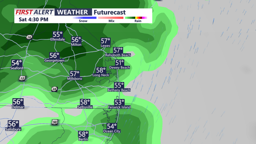
Saturday Afternoon:
Rain will taper off for much of the Delmarva Peninsula by the afternoon, with temperatures warming into the mid-40s to upper 50s. Areas farther north and west, including parts of central and northern New Jersey, may see lingering rain into the evening as a warm front advances.
Impacts:
Nighttime travel could be hazardous, especially on untreated surfaces, before the freeze transitions to rain. Drivers and pedestrians are urged to use caution overnight and during the early morning hours on Saturday.