


DELMARVA - An expansive upper-level trough over the North Atlantic is keeping the Delmarva region locked in a pattern of colder-than-average temperatures and gusty winds as we head into midweek. The combination of a departing surface low near the Canadian Maritimes and an advancing arctic high from the plains is driving strong winds and a tight pressure gradient across the area.
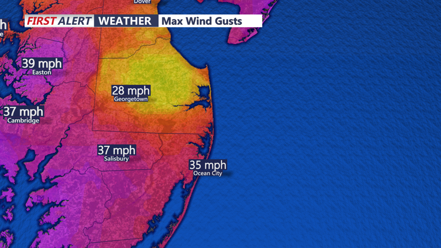
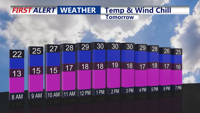
Tuesday night will see temperatures plummet into the teens across much of the region. Combined with sustained winds of 20-30 mph and occasional gusts reaching 40 mph, wind chills will dip into the single digits, with below-zero readings possible in elevated areas.
The gusty winds are expected to ease slightly overnight but will pick up again on Wednesday, maintaining gusts of 25-35 mph, with isolated gusts up to 40 mph possible. A Wind Advisory remains in effect for higher elevations in the southern Poconos through early evening Tuesday due to gusts exceeding 50 mph. While this advisory does not extend to Delmarva, residents should still prepare for blustery conditions.
High temperatures on Wednesday will struggle to rise above the 20s, with wind chills staying in the teens throughout the day. The combination of frigid air and persistent winds will keep outdoor conditions uncomfortable, though no precipitation is expected as shortwaves passing through the upper-level trough bring only intermittent cloud cover.
Looking ahead to Wednesday night and Thursday, temperatures will remain cold, though winds are forecast to ease slightly by Friday as surface high pressure builds into the region. The arctic air mass will keep daytime highs below seasonal averages, with some improvement expected heading into the weekend as the pressure gradient relaxes further.
Residents are advised to bundle up, limit time outdoors, and secure lightweight outdoor objects to prevent them from being blown away. While the week remains dry, the biting cold and gusty winds make it essential to stay vigilant and prepared.