


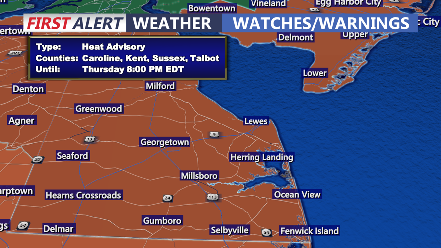


DELMARVA - A very warm and humid air mass will remain entrenched over Sussex County, Delaware, through late Thursday, bringing potentially dangerous heat and several rounds of showers and thunderstorms.
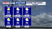
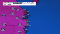
Forecasters say a stationary frontal boundary draped across the northern Mid-Atlantic will lift north as a warm front by Thursday, keeping temperatures in the upper 80s to low 90s and pushing heat index values into the 100- to 105-degree range. Dewpoints are forecast to stay in the mid-70s, making conditions feel oppressive even along the immediate coast, where ocean temperatures near 80 degrees will do little to cool the air.
Scattered showers and thunderstorms are expected to develop Wednesday evening and persist overnight into Thursday. Some storms could be strong, with isolated damaging winds and very heavy rainfall. A Flash Flood Watch remains in effect for areas to the north, but any slow-moving storm cells in Sussex County could produce localized flooding.
On Thursday, the risk for severe thunderstorms will increase, especially northwest of I-95, as drier mid-level air and steep lapse rates create a more unstable environment. Although storms should be more progressive compared to earlier in the week, torrential downpours remain possible. There is uncertainty about the exact timing of storms Thursday, with leftover showers from Wednesday night potentially limiting new development until late in the day.
A cold front is expected to move through overnight Thursday into Friday morning, ushering in drier air and more comfortable conditions to close out the workweek. Humidity will gradually decrease Friday, with dewpoints dropping into the 60s. Highs will still reach the 80s, but the oppressive feel will ease noticeably. Friday night should be pleasant, with lows in the 60s across the area.
Looking ahead, Saturday is forecast to feature seasonable temperatures and lower humidity under the influence of high pressure. However, the weekend could end unsettled as another cold front approaches Sunday, bringing a renewed chance of showers and storms.
Residents are advised to stay alert for heat-related impacts and monitor forecasts for potential severe weather updates.