


Sussex County was blanketed by significant snowfall on Monday, Jan. 6, 2025, with some locations reporting up to a foot of accumulation. The snowstorm caused widespread disruptions to travel and daily activities, prompting officials to urge residents to stay off the roads and exercise caution.
Here’s a detailed breakdown of the snowfall totals reported across Sussex County:
Snowfall Totals Across Sussex County:
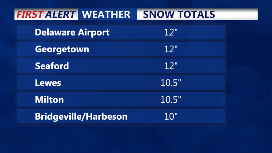
- 3 N Delaware Coastal Airport (Georgetown): 12.0 inches (2:00 PM)
- Georgetown: 12.0 inches (3:42 PM)
- Seaford: 12.0 inches (4:00 PM)
- 1 SW Lewes: 10.5 inches (4:43 PM)
- Milton: 10.5 inches (1:19 PM)
- 1 E Bridgeville: 10.0 inches (12:19 PM)
- Harbeson: 10.0 inches (3:54 PM)
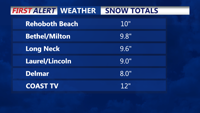
- 1 W Rehoboth Beach: 10.0 inches (4:00 PM)
- Bethel: 9.8 inches (12:45 PM)
- 1 N Milton: 9.8 inches (2:10 PM)
- 2 WSW Long Neck: 9.6 inches (1:00 PM)
- 1 W Georgetown: 9.5 inches (12:10 PM)
- 1 WNW Lewes: 9.4 inches (3:58 PM)
- 2 N Bridgeville: 9.3 inches (4:02 PM)
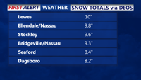
- Ellendale: 9.3 inches (3:59 PM)
- Nassau: 9.3 inches (1:00 PM)
- Stockley: 9.2 inches (4:01 PM)
- Laurel: 9.0 inches (3:09 PM)
- Lewes: 9.0 inches (12:00 PM)
- Lincoln: 9.0 inches (3:41 PM)
- Millville: 9.0 inches (12:00 PM)
- Rehoboth Beach: 9.0 inches (3:39 PM)
- 2 E Seaford: 9.0 inches (12:19 PM)
- 5 W Seaford: 8.4 inches (4:00 PM)
- Delmar: 8.0 inches (12:30 PM)
- Milford: 8.0 inches (1:30 PM)
- 1 E Selbyville: 8.0 inches (12:00 PM)
- 1 SE Dagsboro: 7.8 inches (3:59 PM)
- 2 WSW Laurel: 6.9 inches (3:58 PM)
The heaviest snowfall was recorded in Georgetown, Seaford, and areas near Delaware Coastal Airport, each reporting an impressive 12 inches of accumulation. Other areas, such as Milton, Lewes, and Harbeson, also saw totals exceeding 10 inches, while locations like Delmar and Selbyville experienced between 6 and 8 inches.
Community Response and Road Conditions
Plow crews have been working around the clock to clear major roadways, but many secondary roads remain hazardous. Sussex County officials have advised residents to avoid unnecessary travel and allow snow removal teams the time needed to clear roads effectively. Emergency services continue to monitor conditions across the county.
The snowfall totals were measured and reported by public observers, trained spotters, amateur radio operators, and mesonet monitoring stations under the Delaware Environmental Observing System (DEOS). This collective effort provided an accurate picture of the storm’s impact on the region.
Stay tuned to CoastTV for the latest weather updates and advisories. Follow us on Facebook or visit our website for more information.
