


DELMARVA - Unseasonably cold air will continue to pour into Sussex County late Monday night as a much colder airmass settles over the mid-Atlantic. Skies will be partly to mostly cloudy, and northwest winds around 10 to 15 mph will keep the night feeling raw.
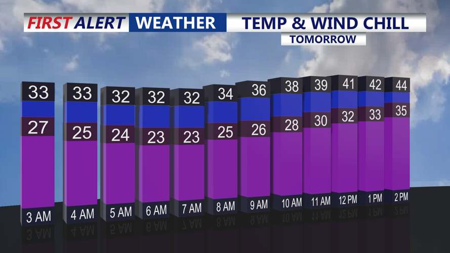
By daybreak Tuesday, actual low temperatures are expected to fall into the mid-20s to near 30 degrees in many inland spots, with upper 20s to low 30s closer to the coast. When combined with 10 to 15 mph winds, Tuesday morning wind chills will dip into the teens and low 20s — likely the coldest feel the county has experienced since March.
Through the day Tuesday, high pressure anchored over the South Central United States will help tighten the pressure gradient over the region, causing winds to ramp back up. Westerly winds will increase to around 20 to 25 mph, with frequent gusts near 40 mph possible across Sussex County. Along the immediate Atlantic coast, occasional gusts may be even higher, making it feel colder than the air temperature suggests.
Afternoon highs Tuesday are forecast to only reach the low to mid-40s, several degrees below normal for mid-November. Skies will be partly to mostly cloudy, adding to the overall chilly, raw feel of the day. No significant rain or snow is expected in Sussex County during this period, though flurries are more likely to stay well to the north of Delaware.
By Tuesday evening and night, winds are expected to gradually ease, though they will remain at 10 to 15 mph out of the southwest. With the coldest air beginning to relax, overnight lows into early Wednesday should be a bit milder than the previous night, generally in the upper 20s to mid-30s, with wind chills holding in the 20s.
Looking ahead, another cold front is expected to cross the region later Wednesday, keeping conditions breezy and cool into Thursday. High pressure then builds back in to end the week and into the weekend, with generally dry weather and temperatures slowly moderating. The next organized chance for rain looks to arrive with a low-pressure system sometime late Sunday into Monday.