


DELMARVA - A cold front off the Delaware coast continues to slowly slide southeastward. Scattered showers and possibly an isolated thunderstorm remain possible across Delmarva this afternoon. However, precipitation should subside through the evening, giving way to a dry and seasonably cool night with lows in the upper 50s to mid-60s in the northwest and mid-60s to low 70s in the southeast.
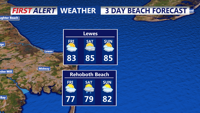
Friday is likely to be the nicest day of the week, with seasonable temperatures, lower humidity, and mostly sunny skies as high pressure continues to build in from the north and west. High temperatures will be in the mid to upper 80s, which is right around the climatological normal for mid to late July, with dew points dropping to the mid-50s to low 60s in the afternoon.
Short Term (Friday Night through Sunday):
The stalled frontal boundary will begin to return northward on Saturday as a shortwave trough nears the region. The trough and associated jet streak will pass through overnight Saturday, then zonal flow returns by Sunday.