


DELMARVA - A fast-moving storm system will impact the Delaware coast Sunday into Monday, bringing intense winds, heavy rainfall, and much colder temperatures. Residents and visitors should prepare for hazardous travel conditions, localized flooding, and rough coastal waters.
Sunday Morning: Increasing Winds and Heavy Rain Develop
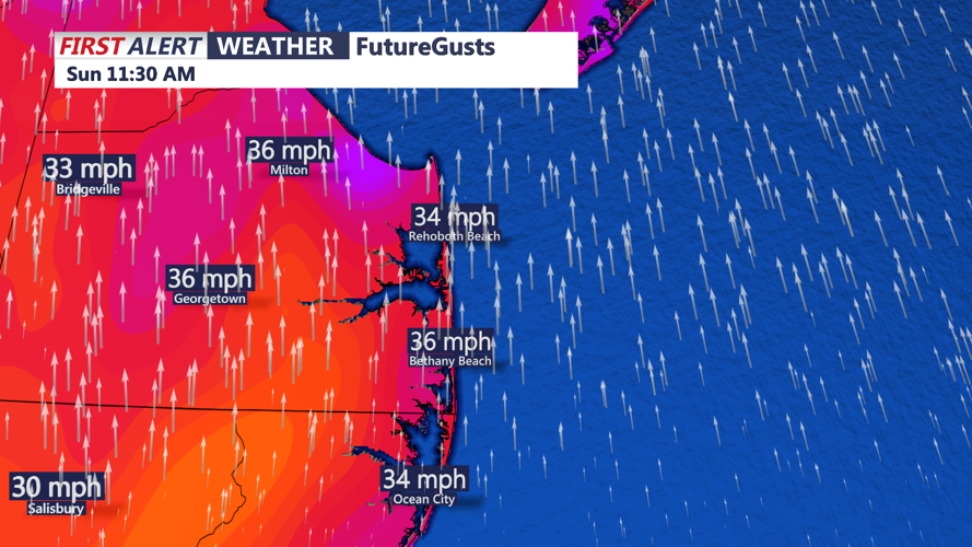
Rain will become widespread early Sunday morning as southerly winds strengthen ahead of an approaching cold front.
- Wind: South winds will increase to 20-30 mph, with gusts reaching 40-50 mph. Stronger gusts up to 55 mph are possible in open areas and near the coast.
- Rain: Periods of heavy rain will move through, with totals between 0.75 and 1.25 inches. Localized flooding in low-lying areas and poor drainage spots is possible.
- Fog: Patchy dense fog could reduce visibility along coastal highways.
Sunday Afternoon: Peak Winds and Cold Front Arrival
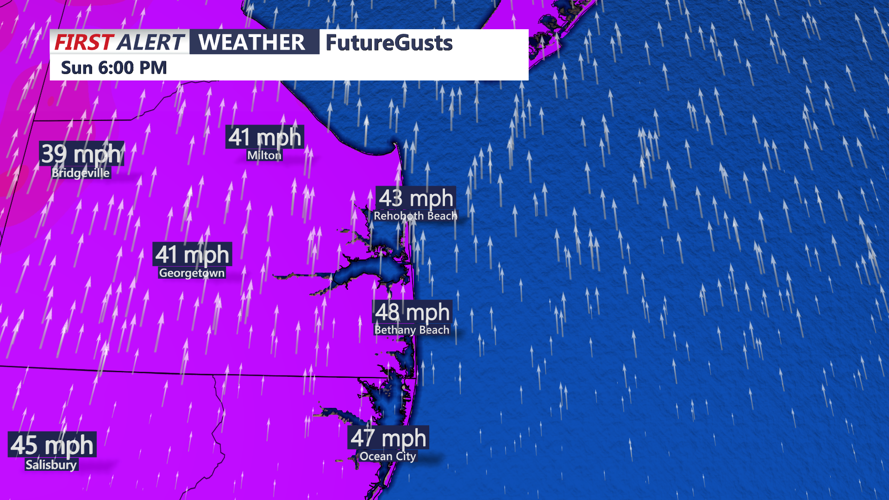
By the afternoon, the strongest winds and heaviest rain will move through as a powerful cold front crosses the region.
- Wind Gusts: The highest gusts of the event will occur in the afternoon, with some areas seeing 50-55 mph gusts, especially inland and along the coastline.
- Rain Tapers Off: The heaviest rain will move offshore by early evening, with lingering showers possible through Sunday night.
- Wind Shift: Winds will abruptly shift to the northwest behind the front, ushering in much colder air.
Sunday Night into Monday: Rapid Cooldown and Clearing Skies
Once the front passes, temperatures will drop significantly, and skies will begin to clear.
- Sunday Night Lows: Temperatures will fall into the upper 30s to low 40s, with gusty northwest winds making it feel even colder.
- Monday: Highs will only reach the low-to-mid 50s, a sharp contrast from Sunday’s warmth. Winds will remain breezy at 15-25 mph before gradually weakening in the afternoon.
Coastal Hazards and Safety Tips
- Strong winds could cause minor power outages and difficult driving conditions, especially on bridges.
- Localized flooding is possible in low-lying areas due to heavy rainfall.
- Boaters should be aware of rough surf and hazardous marine conditions.
Looking Ahead: Milder Midweek Before Another System Arrives
After a chilly start to the week, temperatures will briefly warm up by Wednesday before another cold front approaches late in the week.
Residents and visitors should stay updated with CoastTV for the latest weather alerts and advisories.
