


DELMARVA - A strong cold front will move offshore late Sunday night, bringing an end to the heaviest rainfall. However, lingering showers, gusty winds, and falling temperatures will make for an unsettled night and a challenging Monday morning commute across coastal Delaware.
Late Sunday Night: Rain Gradually Ends, Winds Strengthen
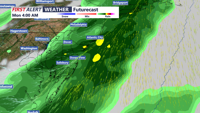
As the storm system pulls away, steady rain will taper off from west to east overnight, but some lingering light showers or drizzle may persist through the early morning hours.
- Rainfall Totals: By the time precipitation ends, most areas will have picked up between 0.75 and 1.25 inches of rain. While widespread flooding is not expected, low-lying areas and roadways with poor drainage could see standing water overnight.
- Wind Shift: Winds will shift from the south to the northwest as the cold front moves offshore.
- Wind Speeds: Gusts of 30-40 mph will persist overnight, with stronger gusts possible along the immediate coast.
Monday Morning: Windy and Much Colder Commute
Commuters heading out early Monday should prepare for blustery conditions, lingering damp roads, and significantly colder temperatures.
- Morning Temperatures: Expect lows in the upper 30s to low 40s, but strong northwest winds will make it feel even colder, with wind chills in the 30s.
- Wind Gusts: Gusty northwest winds will continue at 15-25 mph, with occasional gusts up to 35 mph, making for a brisk start to the day.
- Road Conditions: While heavy rain will have ended, wet roadways and possible ponding in low-lying areas could slow travel. Drivers should also prepare for strong crosswinds, especially on bridges and open highways.
Monday Afternoon into Evening: Chilly and Breezy with Clearing Skies
By Monday afternoon, any lingering clouds will clear out, and the sun will return, but temperatures will remain below average for this time of year.
- High Temperatures: Despite sunshine, highs will only reach the low-to-mid 50s, feeling cooler with continued northwest winds.
- Winds Ease Gradually: While breezy conditions will persist, winds will gradually weaken into the evening, dropping to 10-15 mph by sunset.
Coastal and Travel Impacts
- Marine Conditions: Rough surf and choppy waters will persist Monday, with hazardous boating conditions due to strong offshore winds.
- Falling Tree Limbs: Gusty winds could lead to isolated tree damage or power outages, particularly in areas with saturated soil.
Looking Ahead: Milder Midweek Before Another Storm Late Week
After a chilly Monday, temperatures will begin to moderate by Tuesday and Wednesday, with highs climbing back into the mid-60s. However, another strong cold front is expected to arrive late in the week, bringing another round of rain and gusty winds.
Stay tuned to CoastTV for the latest weather updates and advisories.