



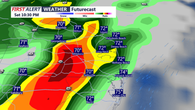

Sussex County will start Saturday with warm sunshine before an approaching cold front turns the day stormy.
Temperatures are expected to rise quickly through the morning, reaching the mid- to upper-80s by early afternoon. Some locations across Delmarva could briefly touch 90 degrees before clouds build and showers and thunderstorms begin to fire.
Storms will develop northwest of the area first, then spread into Delaware and the Eastern Shore during the late afternoon and evening. With humidity high and instability in place, storms could be strong to severe. Damaging winds are the primary threat, though isolated tornadoes cannot be ruled out.
Heavy rainfall is also a concern, with some storms capable of producing one to two inches of rain per hour. The Weather Prediction Center has placed the region under a marginal risk for excessive rainfall, meaning localized flooding is possible in poor-drainage areas.
Storms will gradually diminish overnight into early Sunday as the cold front moves east. Behind the front, cooler air will settle in, with overnight lows falling into the 50s to lower 60s.
By Sunday morning, skies will begin to clear from north to south, but the day will feel noticeably cooler compared to Saturday’s summer-like conditions.
