


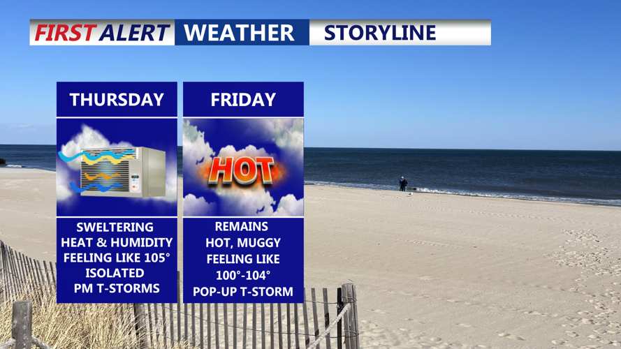


DELMARVA - Starting Thursday morning, Sussex County will remain under the influence of a hot, moist air mass, with a potent combination of heat and severe weather threats likely through early Friday.
Temperatures on Thursday are forecast to climb into the upper 80s to lower 90s. Combined with dewpoints in the mid-70s, heat indices could reach between 100 and 105 degrees across the region, including coastal areas that will see little relief before a sea breeze develops later in the day. Residents are urged to take precautions to avoid heat illness, particularly during the peak afternoon hours.
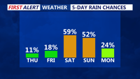
The environment will also be primed for rounds of thunderstorms Thursday afternoon and evening as a cold front approaches from the west. Storms could be more organized and severe than earlier in the week, with the potential for damaging wind gusts, locally heavy rainfall and isolated flooding. Forecast confidence in the exact timing and coverage remains low, as early-day showers could disrupt heating and delay more vigorous development until late in the day or evening.
By early Friday morning, the cold front should sweep through Sussex County, leading to a gradual reduction in heat and humidity. Rain chances will diminish significantly, with only spotty showers possible Friday. Highs will still be warm, ranging from the mid-80s inland to near 90 along the beaches, but dewpoints will finally fall back into the 60s, creating a more comfortable feel.
Friday night and early Saturday will bring a welcome break from oppressive conditions. Lows are expected in the 60s to near 70 degrees, with a light northerly breeze ushering in drier air. Saturday itself looks to be a pleasant midsummer day. Temperatures will hold in the low to mid-80s, and humidity will stay moderate as high pressure settles over the region.
However, the respite may be brief. By Saturday night into Sunday morning, a stalled frontal boundary and a wave of low pressure are forecast to approach from the west. This could bring another round of showers and a few thunderstorms overnight into early Sunday. Although exact timing remains uncertain, conditions will trend more unsettled again as the weekend wraps up.
Forecasters encourage residents and visitors to monitor updated forecasts for changes, especially regarding severe thunderstorm potential Thursday and any rain chances returning late Saturday.