




DELMARVA - Dry weather and increasing sunshine will continue from early Wednesday morning through early Thursday morning as high pressure remains firmly established over the Mid-Atlantic region, setting the stage for noticeably warmer temperatures heading into the weekend.
Wednesday morning will begin on a chilly note, with temperatures in the upper 20s to middle 30s across much of the county. Inland communities, including Salisbury, Georgetown, Seaford, Laurel and Millsboro, will experience some of the coldest readings, while coastal locations such as Ocean City, Lewes, Rehoboth Beach, Bethany Beach and Fenwick Island may remain slightly warmer.
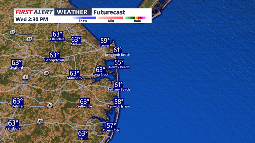
Abundant sunshine will help temperatures recover quickly through the morning, with afternoon highs reaching the upper 50s to lower 60s. Light west to northwest winds generally below 12 mph will accompany the dry and pleasant conditions, making Wednesday favorable for outdoor activities along the beaches.
Wednesday evening will remain mostly clear and tranquil as temperatures gradually fall after sunset. High pressure will continue to suppress cloud development and precipitation, keeping the region dry through the overnight hours.
By early Thursday morning, temperatures will once again settle into the upper 20s and 30s, with the coldest conditions expected inland. Clear skies and light winds will promote efficient overnight cooling, despite the developing warming trend.
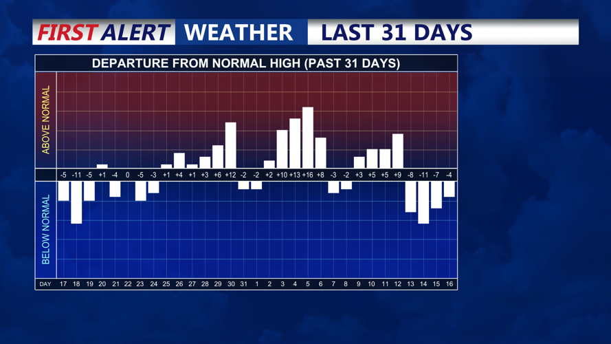
Looking ahead, temperatures will continue climbing Thursday and Friday as an upper-level ridge expands eastward across the eastern United States. Afternoon highs Thursday will reach the 60s, while Friday could bring temperatures approaching 70 degrees in some locations, approximately 10 to 15 degrees above average for mid-November.
Dry conditions are expected to persist through Saturday, although increasing moisture and a developing onshore breeze could bring additional cloud cover to coastal communities.
Attention will then shift toward a potential coastal storm developing off the southeastern United States during the second half of the weekend. While computer models generally agree that an area of low pressure may form, considerable uncertainty remains regarding its strength, timing and track.
Rain chances currently range from 30% to 50% Sunday into early next week. A closer track could bring beneficial rainfall, while a farther offshore path would limit precipitation across Delmarva.
Marine conditions will remain relatively favorable through Saturday, with no significant advisories anticipated. However, increasing winds and building seas could create Small Craft Advisory conditions along the Atlantic coast Sunday if the developing coastal storm approaches the region.
For residents and visitors traveling along the Coastal Highway corridor from Prime Hook and Lewes through Rehoboth Beach, Dewey Beach, Bethany Beach, Fenwick Island, and Ocean City, the remainder of the workweek promises a welcome stretch of sunshine, dry weather and increasingly comfortable afternoon temperatures.
