



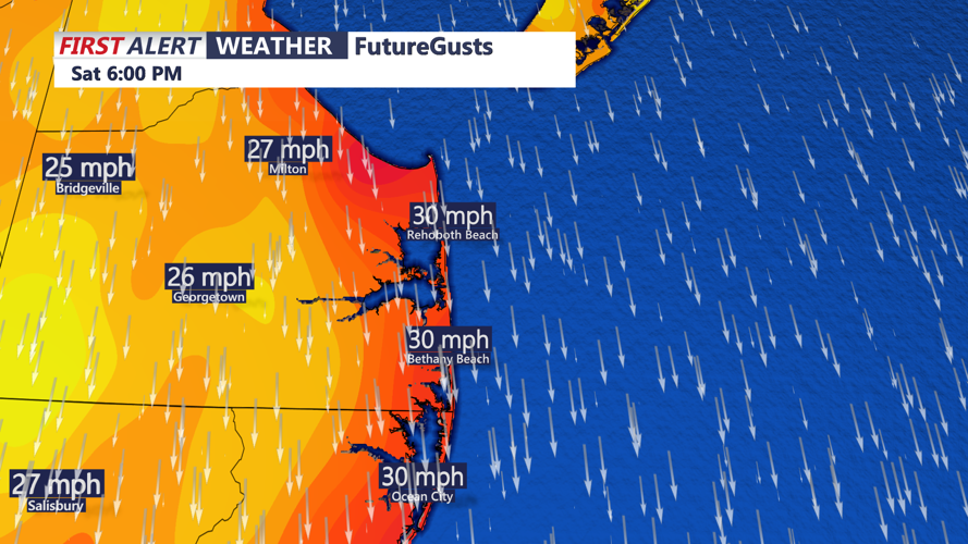

DELMARVA - Saturday morning will be noticeably colder and windy, with temperatures falling into the lower and middle 50s. Northwest winds of 15 to 25 mph will produce gusts of 30 to 40 mph, creating blustery conditions throughout the county.
Drivers, particularly those traveling on exposed roads and bridges near the coast, should remain alert for sudden wind gusts. Loose outdoor objects should also be secured.
Clouds and scattered showers may linger during the morning hours, but drier conditions are expected to gradually develop during the afternoon as high pressure begins building toward the region.
Afternoon temperatures will struggle to climb beyond the lower and middle 50s, a sharp contrast to Friday's highs near 80 degrees. Gusty northwest winds will make conditions feel even colder, especially along Delaware's beaches.
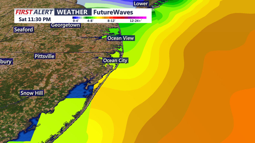
Marine conditions will be particularly hazardous Saturday. Gale Warnings will take effect at 6 a.m. for Delaware Bay and the Atlantic coastal waters, with strong northerly winds and dangerous seas expected.
Along the Atlantic coast from Cape Henlopen to Fenwick Island, winds could gust between 35 and 45 mph over the water, while seas build to 6 to 12 feet. Small vessels will face dangerous conditions, and recreational boaters are strongly encouraged to remain in port.
The Gale Warning for Delaware Bay is scheduled to continue until 6 p.m. Saturday, while warnings for southern Delaware Atlantic coastal waters remain in effect until 6 a.m. Sunday.
Saturday evening into early Sunday morning, skies are expected to clear as high pressure settles across the region. Winds will gradually diminish, allowing temperatures to fall sharply.
Overnight lows across Sussex County are forecast to reach the middle and upper 30s in many communities, with some colder inland locations potentially approaching freezing.
Areas near the immediate coastline should remain somewhat milder because of the influence of the Atlantic Ocean and Delaware Bay.
Although the National Weather Service has issued Freeze Watches for portions of eastern Pennsylvania and northern New Jersey, no frost or freeze watches are currently in effect for Sussex County. We expect lingering winds to limit widespread frost formation locally.
Residents with sensitive outdoor plants should nevertheless monitor temperatures closely, particularly in sheltered inland locations.
Sunday will remain unseasonably chilly, with afternoon highs generally in the 50s despite periods of sunshine.
Looking ahead, we are also monitoring the potential development of a nor'easter off the Mid-Atlantic coast late Sunday into next week. While the storm's eventual track remains uncertain, prolonged northeast winds, rough surf and additional showers could affect coastal communities.
For now, the immediate concern is the combination of strong Saturday winds, dangerous marine conditions and the coldest air of the season settling across southern Delaware.
