


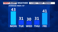

DELMARVA - Sussex County will be plunged into a winter chill Monday through Tuesday as an arctic front ushers in a frigid air mass from Canada. High pressure shifting offshore Monday will allow for a brief warm-up, but conditions will deteriorate as the front moves through late Monday night, bringing gusty winds and an aggressive drop in temperatures.
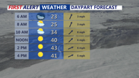
Monday will start relatively mild, with highs in the upper 30s to low 40s and light southwesterly winds under a mix of sun and clouds. However, the arctic front will arrive Monday evening, and while precipitation is unlikely, the temperature plunge will be swift. Overnight lows will fall into the teens and low 20s, with winds increasing behind the front.
Tuesday will be a stark contrast, with daytime highs struggling to reach the freezing mark. Winds from the northwest will intensify, with gusts reaching 30-40 mph, driving wind chill values into the teens during the day. By Tuesday night, wind chills will dip into the single digits and possibly near zero as temperatures bottom out in the teens.
The cold will be compounded by breezy conditions persisting into Tuesday night, creating a potentially hazardous environment for those exposed to the elements. Untreated roads and bridges could see localized icing, and residents are advised to exercise caution while traveling. The biting cold and strong winds may also warrant a Cold Weather Advisory for the region.
Tuesday will mark the onset of a prolonged cold spell, with Canadian high pressure dominating through midweek. While skies may see occasional breaks, the relentless wind and unseasonably cold temperatures will make outdoor activities challenging.
Residents should bundle up and take measures to protect against frostbite and hypothermia during this unusually cold stretch. Ensure pets and livestock have adequate shelter, and monitor vehicles for proper winter preparedness.
As temperatures remain well below seasonal averages, the next significant chance of precipitation isn’t expected until late in the week, when another system may bring a potential mix of rain or snow.