


DELMARVA - Sussex County is in for a dangerously cold stretch late Monday evening through Tuesday evening, with forecasters warning that black ice could form overnight as temperatures fall and any leftover moisture refreezes on untreated surfaces.
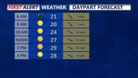
Temperatures are expected to dip to around 20 degrees inland near Georgetown and Seaford and to the low 20s at the coast near Rehoboth Beach, setting the stage for slick travel early Tuesday morning. NWS Mount Holly said overnight refreezing could create “black ice” and that wind chills early Tuesday will be in the single digits across much of the region outside the coldest interior zones.
Northwest winds are expected to increase behind a cold front tonight, with gusts up to around 20 to 30 mph, then remain breezy Tuesday with gusts in the 15 to 25 mph range — enough to make it feel colder than the thermometer reads.
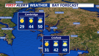
By Tuesday afternoon and into Tuesday evening, skies are expected to stay mostly sunny but cold, with highs near the low 30s inland and at the beaches — about 31–32 degrees from Seaford and Georgetown to Rehoboth and nearby coastal communities.