


Late evening through overnight (10 PM–7 AM) — the main event
This is when Sussex County takes the core hit:
Heaviest snowfall rates are expected late evening through tonight, with bursts that can reach (or exceed) 2 inches per hour in the strongest bands.
NWS warning guidance for Sussex County calls for total snow 13–17 inches (countywide range), with locally higher totals possible where banding persists longest.
Winds crank up dramatically: expect sustained winds generally 20–30 mph with gusts 50–55 mph possible in Sussex (especially exposed/coastal areas).
The combined effect is the headline: whiteouts and drifting. Even where snowfall briefly eases, the wind can keep visibility dangerously low.
Bottom line overnight: snow piles up fast, and travel becomes very difficult to impossible.
Monday morning (7 AM–Noon)
Snow continues, still potentially heavy early, then begins to ease from peak intensity as the storm starts pulling away.
Even if the snowfall rate drops, blowing and drifting remain a major issue—plows can’t “win” quickly when the wind keeps refilling lanes.
Monday midday through late afternoon (Noon–6 PM)
Snow becomes more intermittent and gradually tapers, but hazardous travel can persist because:
drifting continues,
visibility can still dip in squalls,
and plowed/slushy surfaces start to refreeze as temperatures fall later.
Forecast detail for the Georgetown area shows snow mainly before early afternoon, with an additional 1–3 inches possible Monday on top of the bigger overnight totals (the “wraparound”/tail end).
Winds shift more northwest and slowly ease, but gusts can still run up to ~40 mph through the day.
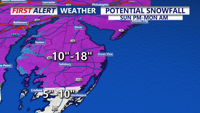
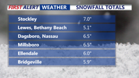
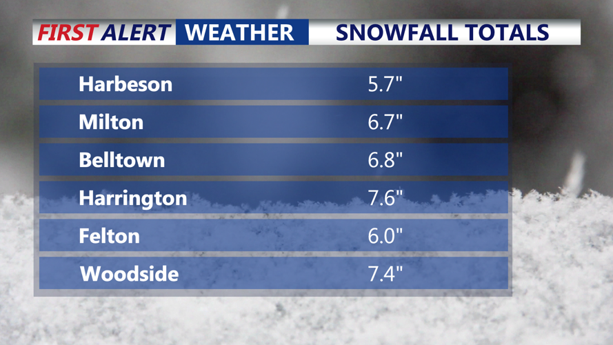
Snowfall expectations (Sussex County)
Expected total: 13–17 inches (Inland Sussex + Delaware Beaches)
Most likely highest totals: where persistent banding sets up (often near/closer to the coast in this setup). The NWS discussion explicitly flags the NJ/DE coastal side as favored for the biggest rates/impacts.
Peak accumulation window: late evening → overnight → early Monday.
Wind impacts (the “blizzard ingredient”)
Worst gusts tonight: up to ~55 mph possible in Sussex County
Wind direction trend: NE/ N tonight → turning NW Monday
Why it matters: the wind will produce widespread blowing snow, rapid drifting, and near-whiteout visibility at times—especially in open areas and on bridges/causeways.
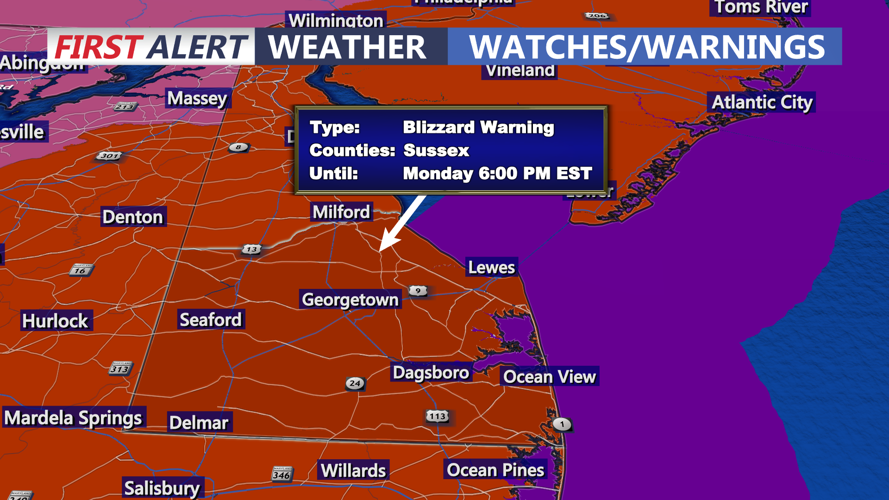
Warnings: what’s in effect and when they end
Blizzard Warning (Sussex County: Inland Sussex + Delaware Beaches)
In effect until: 6:00 PM EST Monday (Feb 23)
Core impacts inside the warning: 13–17" total snow, gusts up to 55 mph, blowing snow/whiteouts, very dangerous travel.
Wind warnings (separate from blizzard?)
For Sussex County specifically, the NWS hazard listing is Blizzard Warning + Coastal Flood Warning (no separate county wind warning headline shown there). Practically speaking: the wind hazard is already “baked into” the Blizzard Warning, and the worst wind aligns with the worst snow tonight.
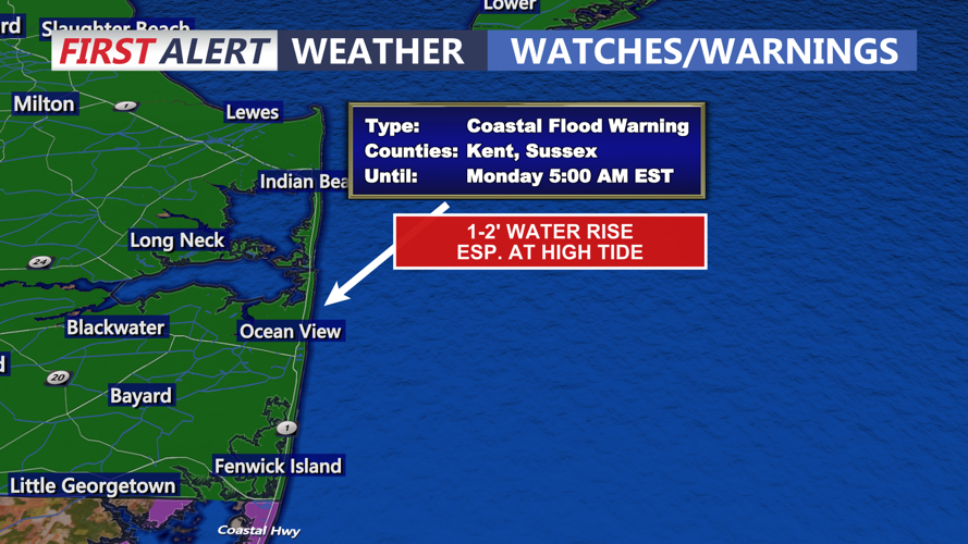
Coastal Flood Warning (Sussex County + beaches)
In effect: 9:00 PM Sun → 5:00 AM Mon
What to expect: 1–2 feet of inundation in low-lying coastal/bayside areas; some roads can become impassable.
Heads-up for Monday: the warning text notes another round of minor to near-moderate flooding is likely with the Monday afternoon high tide, and lingering back-bay flooding could last into Tuesday.
