


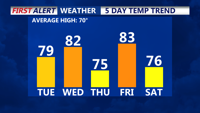

DELMARVA- This afternoon, we'll see the return of a southwesterly flow, with breezes reaching up to 25 mph at times. This will help pull even warmer air into the region, pushing daytime highs into the upper 70s and lower 80s. Clouds will begin increasing late Tuesday ahead of a warm front lifting northward. Higher dew points and rising moisture will keep Tuesday night quite mild, with lows holding in the 60s. There is a chance for a few sprinkles Tuesday night and into Wednesday morning as the front approaches.
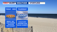
Wednesday will bring a passing cold front that is expected to stall near or over the Delmarva Peninsula. Despite the front's arrival, it lacks a significant push of colder air. Instead, it will mainly dry the atmosphere out, leading to a west-northwest breeze behind it. Highs will remain warm, ranging from the mid 70s to low 80s across most of the region.
Moving into Wednesday night and Thursday, the stalled front may lift back north as a warm front, but rain chances remain low. Lows in the 50s and 60s are expected. High pressure will slide by to the north on Thursday, meaning generally dry and cooler conditions. With a flow off the ocean, humidity levels rise a bit, lowering the fire danger temporarily. Highs will be in the upper 60s to mid 70s.
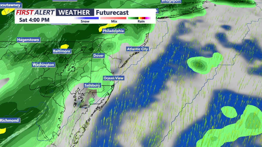
By Thursday night and Friday, another system will approach, bringing a better chance for showers and possibly a few thunderstorms. A low-pressure system moving through the Great Lakes and southern Canada will send a cold front toward Delmarva late Friday into early Saturday. Friday will be quite warm ahead of the front, with highs climbing into the upper 70s to mid 80s and humid conditions in place.
After the cold front crosses early Saturday, there will be a few lingering showers, with temperatures closer to normal seasonal levels for the weekend. Some showers could linger into a part of Sunday. Highs in the mid 70s Saturday, then dropping into the 60s to around 70 for highs on Sunday. Chillier lows Saturday night into Sunday morning with 40s and 50s.