


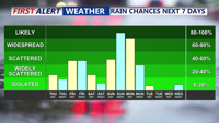


DELMARVA - A shift in the weather pattern begins late Thursday night as a strong cold front sweeps through the region, bringing showers and the chance of isolated thunderstorms to the coast.
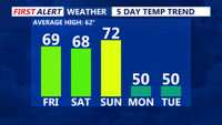
Ahead of the front, temperatures soared into the 70s and even near 80 degrees Thursday in southern Delaware and Maryland’s Lower Eastern Shore. The air turned muggy, with dew points reaching the upper 60s. But change is on the way.
Showers will develop after midnight Thursday and persist into early Friday, with some embedded thunderstorms possible. While a few storms may bring gusty winds, the overall severe threat remains limited. The Storm Prediction Center has placed most of the area under a Marginal Risk for severe weather (1 out of 5). The bigger concern is the potential for localized heavy rainfall, which could lead to brief flash flooding, especially in areas that receive repeated downpours.
By Friday morning, the cold front will likely stall just south of Delmarva, leading to a gradual tapering off of showers. Behind the front, drier and less humid air filters into the region, with dew points dropping into the 50s by the afternoon. Daytime highs will settle into the upper 60s to around 70 degrees for much of Delmarva.
As the weekend approaches, the front will try to lift back northward as a warm front Friday night into Saturday, triggering more clouds and scattered showers. Temperatures Saturday are expected to reach the upper 60s and low 70s, although cloud cover and onshore winds may limit warming. Patchy fog could also develop near the immediate coastline Saturday night.
Sunday will feel more like a return to early summer. Warm air surges back into the area with highs in the 70s to near 80 degrees, especially in inland and southern portions of Delmarva. A stronger cold front is expected to move in Sunday night, bringing another round of showers and the possibility of thunder.
By early next week, another front arrives Monday night into Tuesday, followed by a stretch of cooler, drier weather as high pressure builds in by midweek.
Stay tuned to CoastTV for the latest forecast updates and any watches or warnings issued as this dynamic weather pattern unfolds.