


DELMARVA - A calm and pleasant stretch of summer weather will continue across Sussex County from early Tuesday through early Thursday, thanks to a persistent high-pressure system centered over the northeastern United States.
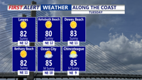
On Tuesday, temperatures will start off below average with morning lows in the upper 50s and lower 60s. The day will feature plenty of sunshine and highs reaching into the upper 70s to near 80 degrees. A northwest breeze will keep humidity levels low, maintaining comfortable conditions throughout the day.
By Tuesday night, the high will gradually shift offshore. Overnight lows will remain mild, settling in the 60s under mostly clear skies. The easterly flow developing on Wednesday may bring in some additional cloud cover, especially near the coast, but no rain is expected. Highs will climb slightly, ranging from the upper 70s to low 80s, while dew points begin to inch upward as humidity slowly returns.
By early Thursday, conditions will remain dry, but a noticeable warm-up will be underway. With the high-pressure system moving farther out into the Atlantic, southerly winds will increase and draw in more moisture. This will mark the beginning of a warmer and more humid period, setting the stage for unsettled weather later in the week.
Residents should enjoy this brief stretch of fair weather before conditions become more typical of midsummer.