


DELMARVA - Rain is expected to arrive across the Delmarva first, spreading north overnight as a weak low pressure system moves across the region. Precipitation will fall as a cold rain south of the I-78 corridor, including all of Sussex County. Areas farther north may mix with snow, but any accumulations are expected to remain under an inch and confined to higher elevations well outside Delaware.
Dry air in place will delay the onset of rainfall in some communities, but moisture moving in from the south should allow steadier rain to reach the ground as the night progresses. Overnight lows will fall into the 30s across the region, with southern areas possibly seeing a slight temperature rise closer to daybreak. Rainfall totals through Wednesday morning are expected to range from a tenth to a half-inch.
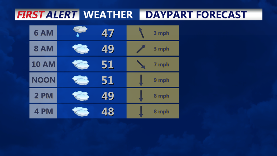
Rain will likely linger into early Wednesday before tapering off from west to east by midmorning. Another tenth to a quarter-inch of rain is possible before the system fully exits. Skies are expected to remain stubbornly cloudy across Sussex County, although some breaks may develop farther north. Highs Wednesday will reach the upper 40s to low 50s under a light north to northeast wind.
By late Wednesday evening, high pressure building over the Northeast will help keep conditions mostly dry, though low clouds may persist. A weak frontal boundary over Delmarva could produce pockets of drizzle, but measurable precipitation is unlikely. Overnight lows will settle into the upper 30s to near 40 degrees.