


The Delmarva region is set to experience a shift in the weather pattern over the coming days, transitioning from fair and calm conditions to more active weather midweek. High pressure will dominate tonight and into Tuesday, but an approaching storm system will bring widespread rain and gusty winds by Wednesday night into early Thursday.
Tonight, high pressure will settle into the region behind a weak cold front, maintaining fair weather conditions with just a few high clouds. Winds that have been gusty during the day will diminish after sunset, becoming light and variable overnight. Temperatures will fall into the mid-30s to low 40s across the area, making for a chilly but quiet night.
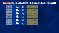
Tuesday will feature increasing cloudiness as a warm front approaches from the southwest. A mid-layer cloud deck will develop during the day, although conditions will remain dry. Winds will stay light, and temperatures will climb into the mid-50s to mid-60s, with the mildest conditions occurring in southern parts of the Delmarva Peninsula.
By Tuesday night, weak high pressure will move offshore, allowing the warm front to draw closer to the region. While most areas will remain dry, a few light showers may develop, particularly in southern areas. Low temperatures will generally stay in the 40s overnight under mostly cloudy skies.
The weather pattern will undergo a significant shift on Wednesday and Thursday as a strong upper-level low pressure system moves into the Mid-Atlantic. During the day on Wednesday, the warm front may bring a few scattered showers, but the bulk of the precipitation is expected to arrive Wednesday night. An occluded front tied to the system will sweep through, bringing widespread showers or a period of steady rain. Rainfall amounts are forecast to range between 0.30 to 0.80 inches across the region, with some locally higher totals of up to 1.25 inches possible in northern areas.
While this rain will not completely resolve ongoing drought conditions, it is a welcome reprieve from the dry weather that has persisted in recent weeks. Georgetown, Delaware, has only received 0.87 inches of rain so far this month, well below the November average of 3.38 inches.
As the front moves through overnight Wednesday into early Thursday morning, colder air will surge into the region, accompanied by a shift in winds from the south to the northwest. Gusty winds are possible during this period, particularly as the pressure gradient tightens behind the departing front. By Thursday morning, temperatures will begin to drop, and cooler air will settle in, marking a sharp contrast to the mild conditions earlier in the week.
The rest of Thursday will remain unsettled as the upper-level low stalls over the Mid-Atlantic, keeping the weather cool and breezy with lingering showers possible. This pattern sets the stage for a chilly end to the workweek, with high pressure expected to return by late Sunday into Monday.