


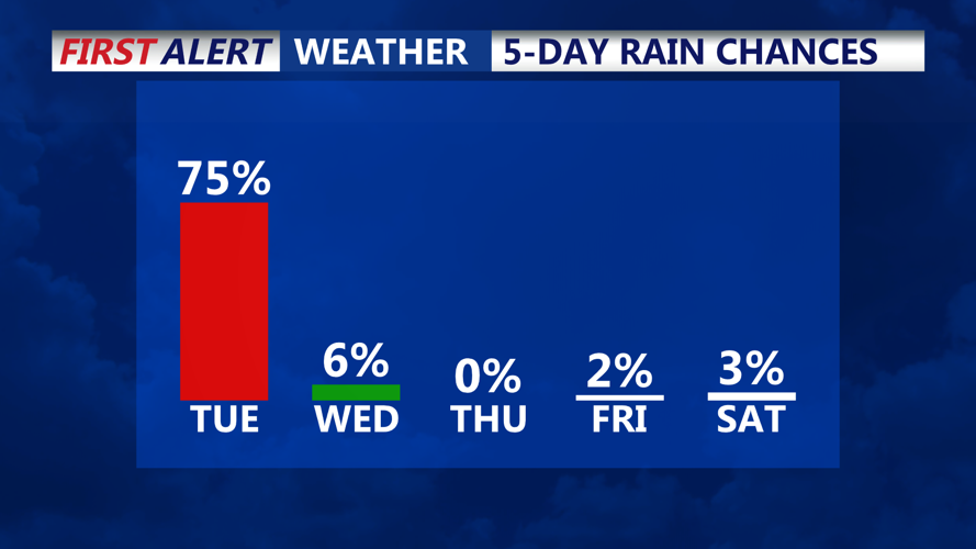


DELMARVA - The most active period begins Tuesday night as a secondary low-pressure system strengthens while moving across Delmarva. Rain is expected to begin in the evening and may become heavy at times, especially during New Year's Eve festivities. Coastal areas could even hear a rumble of thunder due to a narrow band of elevated instability. Rainfall totals are forecasted between 1/4 inch and 1/2 inch, with isolated areas receiving up to an inch closer to the coast.
Rain will taper off from southwest to northeast after midnight as a cold front passes through. Skies will remain mostly cloudy for the rest of the night, with temperatures dropping to the upper 30s to mid-40s.
Wednesday:
By Wednesday, the low-pressure system will move into New England, bringing a strong pressure gradient to Delmarva. Westerly winds between 15-25 mph are expected, with gusts reaching up to 40 mph. Although these winds will fall short of requiring advisories, they will contribute to a brisk day across the region.
High temperatures will reach the 40s to low 50s, but the gusty winds will make it feel colder. Skies will remain partly to mostly cloudy, with the chance for a few lingering rain or snow showers north and west of the I-95 corridor. Accumulations are expected to be minimal, with only a light coating possible in elevated areas.
Wednesday Night and Thursday:
The cold front will usher in a much colder air mass for Wednesday night through Thursday. Skies will clear, but cold air advection will dominate, making it feel colder than the actual temperature due to persistent winds.
Wednesday night’s lows will dip into the mid-20s to low 30s, while Thursday’s highs will struggle to reach the mid-30s to low 40s. Thursday night will see the coldest temperatures of the period, with lows in the upper teens to mid-20s.
While skies will be mostly sunny by Thursday, the wind chill will make it feel below freezing throughout the day and night. Residents should bundle up and prepare for a significant shift from the mild weather earlier in the week.