



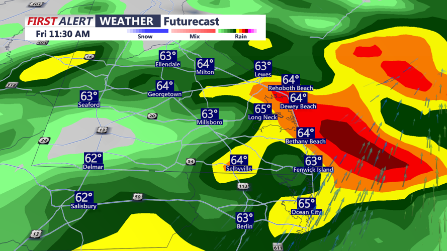

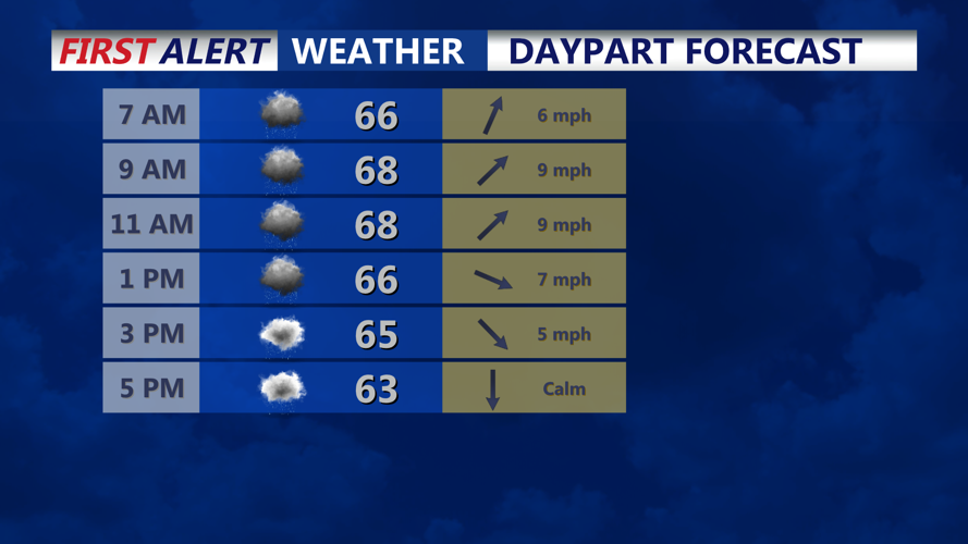


DELMARVA - A slow-moving cold front will bring another round of wet weather early Friday morning, with periods of steady rain continuing through portions of the day before gradually diminishing from west to east Friday afternoon and evening.
Friday morning will begin with widespread clouds, occasional rain and areas of reduced visibility. Communities including Ocean City, Georgetown, Seaford, Laurel, Millsboro, Lewes and Rehoboth Beach can expect damp conditions during the morning commute, with occasional heavier showers possible.
The cold front responsible for the unsettled weather will move slowly across Delmarva, temporarily stalling near the region before resuming its movement toward the Atlantic coast Friday afternoon.
Rainfall totals from the storm system could reach 1 to 2 inches across coastal communities. The rainfall will provide welcome relief following two to three weeks of relatively dry conditions.
Despite the potential for locally heavy rainfall, widespread flooding is not expected. The extended duration of the rain should allow most of the water to drain away gradually. However, ponding remains possible on poorly drained roads, in parking lots and in other low-lying locations.
The greatest concentration of rain Friday morning may occur as the frontal boundary moves slowly toward the coast. Drivers traveling along Coastal Highway, Route 113 and Route 13 should anticipate wet pavement, occasional reduced visibility and potentially slower travel.
By late Friday morning and early afternoon, improving conditions should begin spreading. Rain will gradually taper off as winds shift from the south and southwest to the north and northwest behind the departing front.
Farther east, communities along the beaches, including Ocean City, Lewes, Rehoboth Beach, Dewey Beach, Bethany Beach and Fenwick Island, may experience a slower improvement. Lingering showers, low clouds and occasional mist could persist into Friday afternoon and early evening.
Some coastal locations may not experience substantial clearing before sunset Friday as the slow-moving front continues working offshore.
Temperatures Friday will remain relatively mild early in the day before cooler air begins filtering into the region. Afternoon readings are expected to reach the 60s, with temperatures gradually falling during the evening as northwest winds increase.
By Friday night, the cold front will move farther offshore, allowing drier air to spread. Rain chances will decrease overnight, although some lingering clouds may remain near the coast during the evening.
Skies should gradually clear late Friday night into early Saturday morning, with temperatures falling into the 40s. Some inland communities could experience readings in the lower 40s, while locations closer to the Atlantic Ocean may remain slightly milder.
Along the Delaware Bay and Atlantic coastal waters, marine conditions should improve somewhat Friday as winds and seas temporarily diminish. However, periods of rain and low clouds could continue reducing visibility over the water, particularly during the morning and afternoon.
Boaters should remain alert to changing marine conditions heading into the weekend. Another period of stronger west-northwest winds is expected to develop Saturday into Sunday, with gusts potentially reaching 30 to 35 mph and offshore seas building to 4 to 6 feet. Additional Small Craft Advisories may be necessary.
Saturday will bring a noticeable change in the weather as the front moves away and high pressure begins influencing the region. Most of Delmarva should experience dry conditions with a mixture of sunshine and clouds.
Temperatures will be cooler, with Saturday afternoon highs generally ranging from the upper 50s to middle 60s.
The cooling trend will continue Sunday into early next week, with daytime temperatures primarily in the upper 50s and lower 60s. Overnight lows could eventually fall into the 30s, bringing another taste of late autumn.
For residents and visitors from Prime Hook and Lewes south through Rehoboth Beach, Bethany Beach, Fenwick Island, Ocean City Friday will be a day of gradual transition from unsettled, rainy weather to a cooler and drier weekend.
While western Sussex County and the mid-Shore may begin drying out by midday Friday, the coastal communities could remain cloudy and occasionally damp through the afternoon and evening.
By early Saturday morning, most of the rainfall should be over, setting the stage for a generally dry but cooler weekend.
