


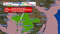

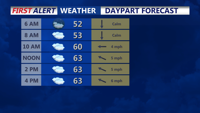

DELMARVA - Wednesday will begin with overcast skies and a chance of early morning drizzle or light showers across Delmarva. Rainfall totals during the morning will be minimal, with most areas picking up less than 0.03 inches. Following the morning rain, there will be a brief lull in precipitation, though the gray skies will persist throughout the day. A stalled warm front across the region may lead to a sharp temperature divide, with highs reaching near 70 degrees in southern Sussex County, while areas farther north remain cooler, struggling to break 50 degrees. Winds will be light and variable in the morning, turning southeast by the afternoon.
Rain chances will increase again by late Wednesday afternoon and into the evening as a strengthening low-pressure system approaches from the west. This system will bring widespread and much-needed rain to the area. By Wednesday night, steady rain will develop, lasting through much of Thursday. Periods of moderate to heavy rain are possible, particularly during the day Thursday, with rainfall amounts likely to exceed 1 inch in some locations.
A strong upper-level trough will accompany this storm system, deepening the low pressure as it lingers across the Mid-Atlantic through Thursday into Friday. While the heaviest precipitation will fall as rain across Delmarva, colder air to the north will result in snow accumulation in the higher elevations of the Poconos and far northern New Jersey.
Thursday will remain breezy and rainy, with temperatures hovering in the 50s for most of Delmarva. The unsettled weather will persist into Friday as the system slowly moves out of the region. Residents should prepare for wet and windy conditions midweek, along with occasional ponding on roads during periods of heavier rain. The much-needed rainfall will help alleviate recent dry conditions across the area.
