


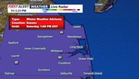
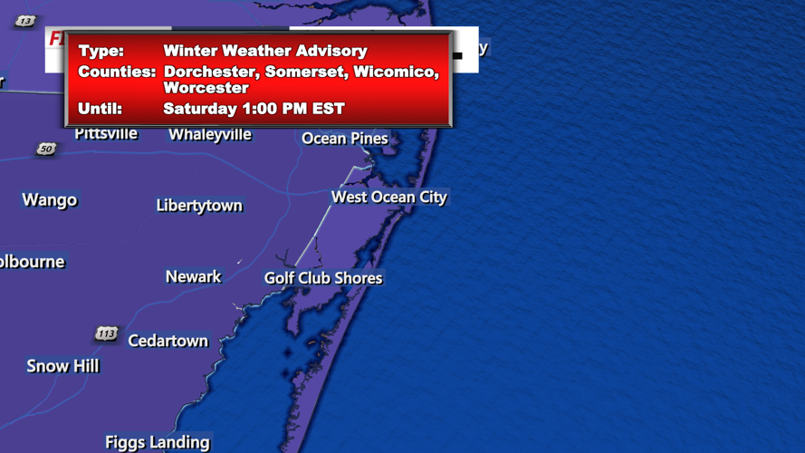
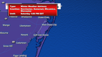

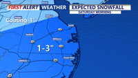

DELMARVA - A Winter Weather Advisory has been issued for Sussex County, Delaware, as light snow is expected to impact the region beginning after midnight tonight. Ocean City, Maryland, and surrounding areas will also experience snowfall, with accumulations ranging from a dusting to 2 inches. The advisory remains in effect until 9 a.m. Saturday, with snowfall likely to taper off by mid-morning.
High pressure currently situated over the eastern Great Lakes will shift off the East Coast tonight, allowing an area of low pressure near New Orleans to track northeastward, exiting off the Mid-Atlantic coast early Saturday morning. This system will bring snow to the area overnight, followed by colder and gusty conditions as it departs.
Hourly Weather Expectations:
Friday Evening (8 p.m. - Midnight):
- Clear and cold conditions with temperatures falling to the mid-20s by midnight.
- Winds light at 5–10 mph, making for calm weather before snowfall begins.
Saturday Early Morning (12 a.m. - 6 a.m.):
- Midnight to 2 a.m.: Light snow begins moving in from the southwest, spreading across Sussex County and Ocean City. Initial accumulations will be minor, with most roads remaining wet.
- 2 a.m. to 4 a.m.: Snow intensifies slightly, particularly in Sussex County and Cape May County, with visibility reduced to about a mile at times. Accumulations reach 0.5 to 1 inch in some spots.
- 4 a.m. to 6 a.m.: Snow continues steadily, with an additional 0.5 to 1 inch of accumulation likely in areas under the Winter Weather Advisory. Temperatures hover in the upper 20s to low 30s, leading to slick spots on untreated roads.
Saturday Morning (6 a.m. - 12 p.m.):
- 6 a.m. to 9 a.m.: Snow begins to taper off, lingering longest along coastal areas such as Ocean City. Total snow accumulations of 1 to 2 inches are expected in Sussex County, while areas further inland and south will see a dusting to 1 inch.
- 9 a.m. to 12 p.m.: Skies begin to clear as the low-pressure system moves offshore. Winds increase from the northwest at 15–20 mph, with gusts up to 25 mph. Temperatures remain cold, ranging from the upper 20s to low 30s.
Saturday Afternoon and Evening:
- Clearing skies and gusty winds persist. Highs will reach the low 30s, but wind chills will make it feel closer to the teens. Travel conditions should improve as road treatments take effect and snow melts on primary roads.
Winter Weather Advisory Details:
The Winter Weather Advisory issued for Sussex County highlights the potential for up to 2 inches of snow, especially near coastal regions. The advisory warns of slippery road conditions and reduced visibility during the early morning hours, urging caution for motorists.
Looking Ahead:
After the snow clears, high pressure will build back into the region, bringing a calm but cold Sunday with temperatures in the low 30s to low 40s. Winds will gradually subside, offering a quieter end to the weekend. However, a reinforcing shot of cold air is expected to arrive Tuesday into Wednesday, ensuring the winter chill remains in place.
