


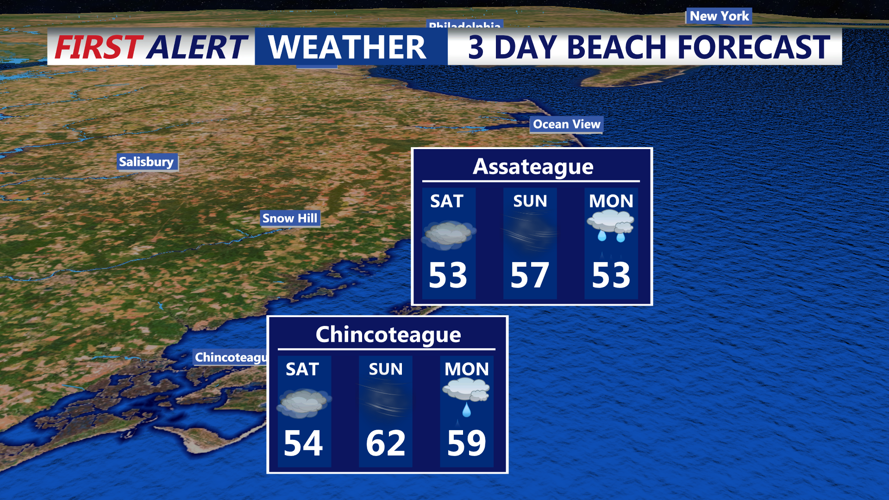
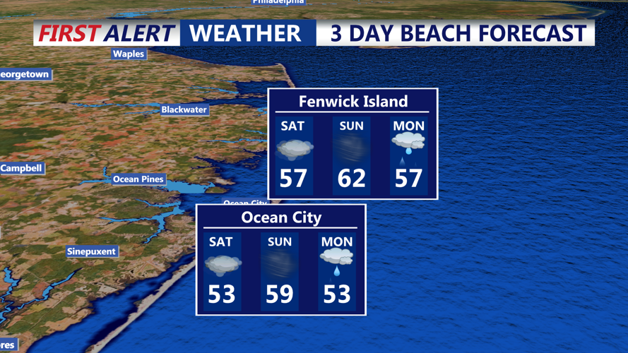
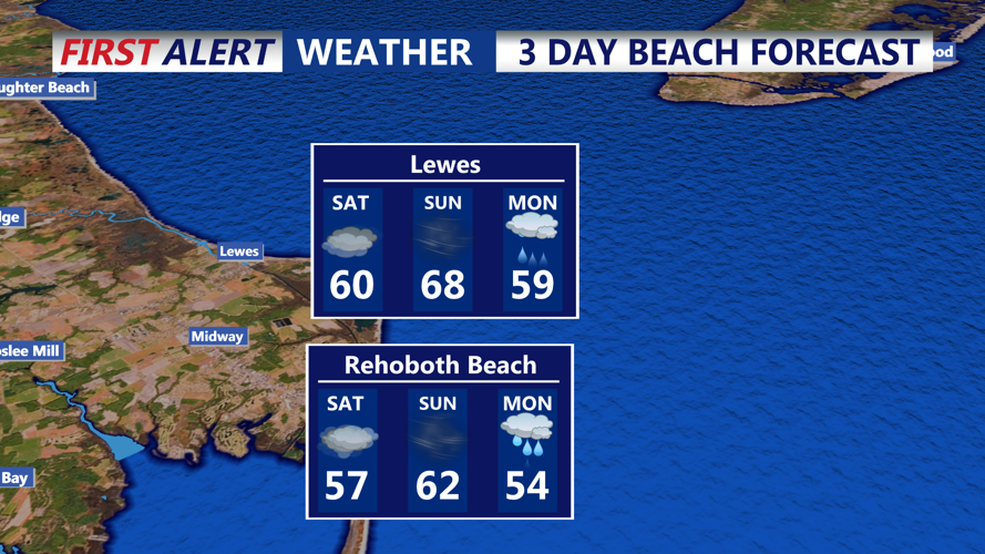

DELMARVA - Beach communities in Delaware should brace for an active weather pattern this weekend as a strengthening storm system approaches. While Saturday afternoon will be mild and breezy, conditions will deteriorate overnight into Sunday, with strong winds, heavy rain, and the potential for localized flooding.
Saturday Afternoon: Mild but Breezy
Saturday afternoon will remain mostly cloudy with a few breaks of sunshine as a warm front continues lifting northward. Winds from the southeast will increase to 10-20 mph, with occasional gusts up to 30 mph. Temperatures will climb into the mid-to-upper 60s, making for a relatively warm day along the coast.
As moisture levels rise, areas of fog may develop in the evening, particularly near the beaches. Drizzle is possible overnight, but significant rain is not expected until Sunday.
Sunday: Strong Winds and Heavy Rain Develop
Sunday will start cloudy and mild, with temperatures in the upper 60s to low 70s. However, conditions will rapidly change as a powerful cold front approaches from the west.
- Wind: Southerly winds will strengthen throughout the day, with sustained speeds of 20-30 mph and gusts reaching 40-50 mph by the afternoon. Some isolated gusts near 55 mph are possible, especially inland.
- Rain: Heavy rain will begin in the late morning and continue through the afternoon. Most areas will see between 0.75 and 1.25 inches of rainfall, with localized roadway flooding possible.
- Storm Potential: A narrow line of showers and possible thunderstorms will move through ahead of the cold front. While lightning may be limited, damaging wind gusts are possible within this line.
Coastal Concerns and Safety Precautions
- Rough surf and hazardous marine conditions will develop as strong onshore winds persist.
- Coastal flooding is possible in vulnerable areas, especially during high tide cycles.
- Motorists should prepare for reduced visibility in heavy rain and fog, along with strong crosswinds on bridges and open roads.
Looking Ahead: Clearing and Cooler by Monday
As the cold front moves offshore Sunday night, rain will taper off, and winds will shift to the northwest. Monday will be noticeably cooler, with highs in the mid-50s and clearing skies.
Residents and visitors should stay alert for potential wind advisories and flood warnings. Stay tuned to CoastTV for the latest updates.
