


DELMARVA - A developing low-pressure system will bring changing weather conditions to Sussex County from Wednesday through Friday, impacting travel and outdoor activities.
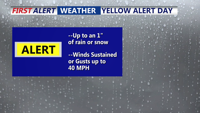
Wednesday will begin with cloudy skies and cold temperatures, with highs only reaching the mid-30s. By late morning into the afternoon, precipitation is expected to develop across the region, starting as light snow or sleet inland before transitioning to freezing rain and rain. Coastal areas are expected to see mostly rain. Road conditions may become slick, particularly on untreated surfaces, bridges, and overpasses. Residents are advised to dress in warm layers and allow extra time for evening travel.
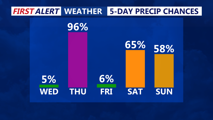
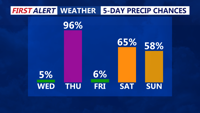
By Thursday, a strong southeasterly flow will push warmer air into the region, raising temperatures to the mid-50s. Rain is expected throughout the day, with heavier showers possible in the morning and early afternoon. Some isolated thunderstorms cannot be ruled out, particularly along the coast. Winds will also increase, with gusts up to 30 mph, making for a damp and blustery day. Umbrellas and waterproof clothing are recommended for those spending time outdoors.
As the system moves offshore late Thursday into Friday morning, colder air will filter back into Sussex County. Highs on Friday will remain in the low 50s, but temperatures will drop sharply by the evening, reaching the upper 20s overnight. The return of colder conditions could lead to refreezing on roads and sidewalks, creating the potential for icy spots Friday night into early Saturday.
Residents should stay updated on changing weather conditions and be prepared for varying precipitation types. Drivers should use caution, especially during the transition periods on Wednesday and Friday when road conditions may be slick.