


DELMARVA - Frigid conditions will grip Sussex County, Delaware, and Ocean City, Maryland, from Thursday through Saturday as the effects of a departing coastal storm linger across the region. The storm, which brought light snowfall and gusty winds Wednesday night, will continue moving further out to sea, allowing a reinforcing shot of cold air to settle into the Mid-Atlantic. In its wake, a strong northwesterly wind will persist, keeping wind chills in the single digits and teens, with occasional gusts between 25-35 mph making it feel even colder.
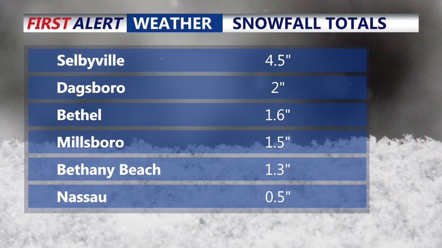
Snowfall totals across Sussex County ranged from 4.5 inches in Selbyville, 2 inches Dagsboro, 1.3 inches in Bethany Beach to barley anything north of Milton. The "jackpot" zone so to speak was across southern portions of the peninsula.
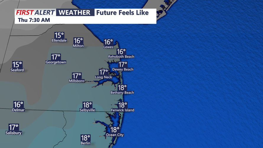
While significant snowfall is not expected, scattered snow showers may develop at times on Thursday afternoon and into the evening as an upper-level disturbance moves across the area. Any accumulations will be light, generally less than an inch, but could briefly reduce visibility on local roadways. As temperatures struggle to climb above the mid-20s on Thursday, wind chills will remain a factor throughout the day, making for bitterly cold conditions, particularly during the morning and evening hours.
By Friday, high pressure will begin building into the region, bringing clearer skies but maintaining cold temperatures. Morning lows will once again dip into the upper teens, and daytime highs will remain in the upper 20s to near 30 degrees. The pressure gradient between the departing storm and the incoming high will still keep winds elevated, though gusts will gradually diminish by the afternoon. Wind chills will stay in the teens through much of the day, reinforcing the need for layered clothing and precautions against prolonged exposure to the cold.
Saturday will bring a slight moderation in temperatures as high pressure settles in more firmly, allowing winds to ease and sunshine to increase. Morning lows will remain in the teens, but highs will push into the mid-30s, marking the beginning of a slow warming trend. Despite the improvement, temperatures will still be below seasonal averages, and wind chills will linger in the 20s during the early part of the day. The high-pressure system will dominate through the weekend before another low-pressure system begins to take shape in the Great Lakes early next week, potentially bringing the next chance for precipitation to the region.
Residents should continue to prepare for dangerously cold wind chills, especially on Thursday and Friday, and remain cautious on roadways as occasional snow showers could create slick spots. The extended cold snap will keep the region in winter’s grip for a few more days before a slight rebound in temperatures arrives later in the weekend.