


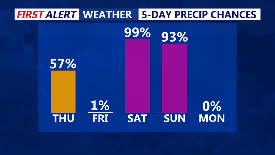


DELMARVA - Rainfall from the departing low-pressure system will linger into early Thursday morning before gradually ending from west to east. By sunrise, most of the steady rain will have moved offshore, leaving behind damp roads and lingering clouds. Patchy drizzle or a few isolated showers may persist through mid-morning, especially closer to the coast.
Temperatures will remain mild ahead of the cold front, with morning lows in the mid-to-upper 40s. Winds will be out of the southwest early in the day but will shift to the west as the front passes. By late morning, skies will begin to clear, and drier air will move in. High temperatures will reach the upper 40s to low 50s in Sussex County and Ocean City before cooler air arrives in the evening.
By Thursday night, winds will increase out of the west-northwest, becoming breezy with gusts of 25 to 30 mph. Overnight lows will drop into the upper 20s to near 30 degrees, making for a much colder start to Friday.
Friday will bring mostly sunny skies but cooler conditions as high pressure builds into the region. Despite the sunshine, temperatures will struggle to climb out of the mid-to-upper 30s, with breezy northwest winds making it feel even colder. Gusts of 20 to 25 mph will persist through much of the day before gradually diminishing in the evening.
By Friday night, high pressure will settle over the area, bringing lighter winds and clear skies. Overnight lows will fall into the low-to-mid 20s, with some areas of inland Sussex County dipping into the upper teens.
Saturday will begin with plenty of sunshine, but clouds will gradually increase as the next weather system approaches from the west. Winds will turn southerly by the afternoon, helping to bring slightly milder air back into the region. High temperatures will rebound into the low-to-mid 40s, though increasing cloud cover may limit warming later in the day.
By Saturday night, a developing low-pressure system will track toward the Mid-Atlantic, bringing the next chance of precipitation. Rain is expected to develop late Saturday night into Sunday morning, though exact timing and precipitation amounts remain uncertain.
Residents should prepare for a shift to colder and breezier conditions following Thursday’s rain. Those with outdoor plans Friday and Saturday should dress for chilly temperatures, especially in the mornings. Travel impacts will be minimal, but wet roads early Thursday and gusty winds Thursday night into Friday could create brief hazards for drivers.